Dominion Atlantic Railway Digital Preservation Initiative - Wiki
Use of this site is subject to our Terms & Conditions.
Stillwater
Stillwater, Nova Scotia
Mile 19.55 from Windsor Junction on the Halifax Subdivision (Mile 35.31 from Halifax)
- Next Station East: Stillwater Lake
- Next Station West: Ellershouse
Facilities & Features
- Station shelter and platform on south side of mainline
- 1,380 foot passing siding
- 700 foot, 15 car spur to Stillwater Sawmill, north side of mainline, east facing switch
- 23 foot Plate Girder Bridge over Stillwater Brook, Mile 19.95
- Water tank and coal shed (1860s and 1870s)[1]
- Mile 20.85 - Dawson siding for Dawson Brook Mill, stone loading dock[2]
Commerce & Industry
According to a community information "Upshore Downshore Summer/Fall 1999" There was a siding which went to a sawmill which was originally build and operated by Montague Grant along with his partner Adolph Von Guzman. They had also opened another mill just off the main rail line crossing the St Croix River but it doesn't mentioned if it's near Mantua or St Croix.
Description & History
Stillwater was named after the Stillwater Brook which paralleled the railway for several hundred feet and crossed under the DAR mainline at the site of community. The arrival of the Nova Scotia Railway in 1858 (later to become the Windsor Branch of the DAR) opened up timber production in the forests and lakes around Stillwater. A number of sawmills with their own sidings surrounded the community which grew beside the tracks and included a large mill with its own siding and a school house. Stillwater was a regular station stop in the early years of the line and also included a coal shed and water tower for locomotives. Two spurs to other mills were located just east of Stillwater and another was located just west of Stillwater leading to Adams mill on Five Mile Lake just to the southeast of Stillwater.
However by the 1920s, most of the mills went out of operation and the community became a small seasonal logging and recreational fishing settlement served by a flag stop shelter and platform. Five Mile Lake was dammed in 1922 to provide a controlled water source for hydro power, which moved the coastline of the lake right beside the DAR line just east of Stillwater.[3] This created a second nearby community of waterfront fishing cabins called Stillwater Lake.
Gallery

Detail from A. F. Church Map, "Hants County", showing the route of the Nova Scotia Railway through Stillwater and Ellershouse, 1869.

DAR line from Newport to Mount Uniacke, detail from 1909 geological map showing Hartville, Dawson Siding, Stillwater and Claremont's.
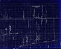
1918 Track Chart of Stillwater
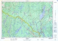
Topographic map from Stillwater to Windsor Junction circa 1956.


References & Footnotes
- ↑ http://sites.rootsweb.com/~nshants/resources/map/afchurch/hants/ch_4b.pdf A. F. Church Map, "Hants County" 1869, Hants County, Nova Scotia GenWeb Project]
- ↑ 1919 DAR Employee Time Table at the Canadian Pacific Historical Association Documents Library
- ↑ Gillian Fielding, "Barriers to Fish Passage in Nova Scotia: The Evolution of Water Control Barriers in Nova Scotia’s Watershed", table A.1, page 63
External Links
"Stillwater Station", Place-names and Places of Nova Scotia, Nova Scotia Archives</ref>