Dominion Atlantic Railway Digital Preservation Initiative - Wiki
Use of this site is subject to our Terms & Conditions.
Difference between revisions of "Hartville"
From DARwiki
Dan conlin (talk | contribs) (shelter) |
|||
| (11 intermediate revisions by 2 users not shown) | |||
| Line 1: | Line 1: | ||
| + | __NOTITLE__ __NOTOC__ | ||
=Hartville, Nova Scotia= | =Hartville, Nova Scotia= | ||
| − | + | Mile 24.52 from [[Windsor Junction]] on the [[:Category:Subdivision Halifax|Halifax Subdivision]] (Mile 40.33 from [[Halifax]]) | |
| − | *[[: | + | |
| − | + | *Next Station East: [[Ellershouse]] | |
| + | *Next Station West: [[Newport]] | ||
| + | |||
| + | ==Facilities & Features== | ||
| + | * [[Hartville Bridge]], across the St. Croix River. | ||
| + | * Small Shelter and platform, south of track, just east for bridge | ||
| + | |||
| + | ==Commerce & Industry== | ||
| + | |||
| + | ==Description & History== | ||
| + | |||
| + | ==Gallery== | ||
| + | <Gallery perrow=5> | ||
| + | File:Newport-MtUniacke1909.jpg|DAR line from [[Newport]] to [[Mount Uniacke]], detail from 1909 geological map showing [[Hartville]], Dawson Siding, [[Stillwater]] and [[Claremont's]]. | ||
| + | File:HA-24.58 Hartville.jpg|1918 Track Chart of Hartville | ||
| + | File:Windsor_21_A16_East.jpg|Topographic map from Falmouth to Ellershouse circa 1956. | ||
</Gallery> | </Gallery> | ||
| + | |||
| + | ==References & Footnotes== | ||
| + | *[[1969-MemoOfGenInfo|1969 Memorandum of General Information]] | ||
| + | <references /> | ||
| + | |||
| + | ==External Links== | ||
| + | |||
[[Category:Locations]] | [[Category:Locations]] | ||
| − | [[Category:Subdivision | + | [[Category:Subdivision Halifax|HA-24.58]] |
Latest revision as of 14:11, 16 November 2020
Hartville, Nova Scotia
Mile 24.52 from Windsor Junction on the Halifax Subdivision (Mile 40.33 from Halifax)
- Next Station East: Ellershouse
- Next Station West: Newport
Facilities & Features
- Hartville Bridge, across the St. Croix River.
- Small Shelter and platform, south of track, just east for bridge
Commerce & Industry
Description & History
Gallery
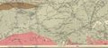
DAR line from Newport to Mount Uniacke, detail from 1909 geological map showing Hartville, Dawson Siding, Stillwater and Claremont's.
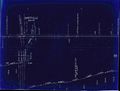
1918 Track Chart of Hartville
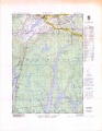
Topographic map from Falmouth to Ellershouse circa 1956.


References & Footnotes