Dominion Atlantic Railway Digital Preservation Initiative - Wiki
Use of this site is subject to our Terms & Conditions.
Difference between revisions of "Aylesford"
From DARwiki
Dan conlin (talk | contribs) (→Gallery: image) |
|||
| Line 21: | Line 21: | ||
File:Berwick_21_H2_West.jpg|Topographic map from Auburn to Aylesford circa 1956. | File:Berwick_21_H2_West.jpg|Topographic map from Auburn to Aylesford circa 1956. | ||
Image:Train No. 95.jpg|Dayliner [[Train No. 95]] en route to [[Yarmouth]] in first week of service at [[Aylesford]] August 27, 1956. | Image:Train No. 95.jpg|Dayliner [[Train No. 95]] en route to [[Yarmouth]] in first week of service at [[Aylesford]] August 27, 1956. | ||
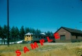
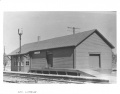
| + | File:DAR - Aylesford Station end view-Harold Jenkins Photo-September 1958.JPG|[[Aylesford Station]] west end, September 1958. | ||
Image:DAR8133a.jpg|CPR [[CPR8133|No. 8133]] wayfreight en route to [[Annapolis Royal]] at [[Aylesford]] in August 1959. | Image:DAR8133a.jpg|CPR [[CPR8133|No. 8133]] wayfreight en route to [[Annapolis Royal]] at [[Aylesford]] in August 1959. | ||
Image:Aylesford Looking East 1975 a.jpg|[[Aylesford]] looking east in 1975. | Image:Aylesford Looking East 1975 a.jpg|[[Aylesford]] looking east in 1975. | ||
Revision as of 15:11, 8 October 2018
Aylesford, Nova Scotia
Subdivision Kentville, Mile 17.5
Facilities & Features
Commerce & Industry
Description & History
Operations & Orders
Gallery

Aylesford to Kingston Aerial.
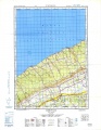
Topographic map from Auburn to Aylesford circa 1956.
Dayliner Train No. 95 en route to Yarmouth in first week of service at Aylesford August 27, 1956.
Aylesford Station west end, September 1958.
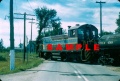
CPR No. 8133 wayfreight en route to Annapolis Royal at Aylesford in August 1959.
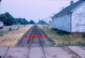
Aylesford looking east in 1975.
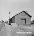
Aylesford Station circa 1959 to 1963.

VIA Rail sand platform at Aylesford. April, 1986.

VIA Rail sand platform at Aylesford. April, 1986.


References & Footnotes
- Alexander MacNab, Windsor and Annapolis Railway, Report of Alexander MacNab Nov 1, 1873
- 1969 Memorandum of General Information