Dominion Atlantic Railway Digital Preservation Initiative - Wiki
Use of this site is subject to our Terms & Conditions.
Difference between revisions of "Windsor"
Sarah Taylor (talk | contribs) (→Gallery: added File:Windsor Water Street.jpg) |
Sarah Taylor (talk | contribs) m (→Gallery: changed to a different file File:Windsor Train on Water Street, Heading for Station - 1927 - 1.jpg) |
||
| Line 55: | Line 55: | ||
Image:Avon River bridge curve.jpg|Eastern approach tracks to the [[Avon River Bridge]] from downtown [[Windsor]], in 1918, sharpest curve on the DAR. | Image:Avon River bridge curve.jpg|Eastern approach tracks to the [[Avon River Bridge]] from downtown [[Windsor]], in 1918, sharpest curve on the DAR. | ||
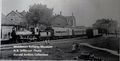
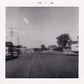
| − | File:Windsor Water Street.jpg|A passenger train approaches [[Windsor Station]] on the street trackage on Water Street, July 1, 1927. (60 years of Confederation.) | + | File:Windsor Train on Water Street, Heading for Station - 1927 - 1.jpg|A passenger train approaches [[Windsor Station]] on the street trackage on Water Street, July 1, 1927. (60 years of Confederation.) |
Image:Train No. 95 leaving Windsor for Yarmouth 8-49.jpg|[[Train No. 95]] leaving [[Windsor]] for [[Yarmouth]] in August 1949. | Image:Train No. 95 leaving Windsor for Yarmouth 8-49.jpg|[[Train No. 95]] leaving [[Windsor]] for [[Yarmouth]] in August 1949. | ||
Revision as of 11:31, 14 February 2022

Mile 31.60 from Windsor Junction on the Halifax Subdivision (Mile 47.32 from Halifax)
Mile 0 Subdivision Truro
Elevation: 29 feet above sea level[1]
- Next Station West: Falmouth
- Next Station East (to Truro): Dimock's
- Next Station East (to Halifax): Pembertons
Facilities & Features
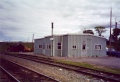
- Windsor Station
- Windsor Freight Shed
- Windsor Railyard
- Windsor Enginehouse
- Windsor Track Scale
- Windsor Water Tower
- Windsor Diesel Fueling
- Windsor Wharves
- Avon River Bridge
Description & History
Commerce & Industry
Windsor Wear textile factory
L. A. Armstrong Apple Warehouse
B. Sexton Apple Warehouse
Gallery
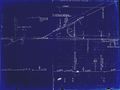
1918 Track Chart of Windsor
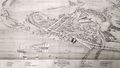
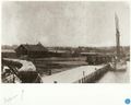
Bird's Eve View of Windsor Nova Scotia 1878 showing the town of Windsor with Windsor Station centre and the Avon River Bridge in the lower right, 1878.
The Windsor Enginehouse and the circular structure covering the turntable, with the Windsor Cotton Mill in background, circa 1884.
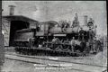
Windsor & Annapolis No. 10, later DAR No. 12 & train at the Windsor Station, circa 1891.
A passenger train running in the street at Windsor, sometime prior to July, 1905.
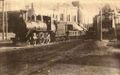
A freight train running in the street at Windsor.

Gypsum quarry spurs in the Windsor, Dimock's and Newport areas, from geological map, 1909.
Locomotive No. 380 with crew on the turntable at the Windsor Enginehouse, 1912.
Windsor Wharves with DAR gypsum cars and box cars in foreground and the L. A. Armstrong Apple Warehouse in background, pre-1914.

Eastern approach tracks to the Avon River Bridge from downtown Windsor, in 1918, sharpest curve on the DAR.
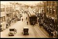
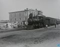
A passenger train approaches Windsor Station on the street trackage on Water Street, July 1, 1927. (60 years of Confederation.)
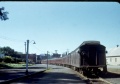
Train No. 95 leaving Windsor for Yarmouth in August 1949.
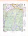
Topographic map from Falmouth to Ellershouse circa 1956.
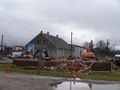
Mainline through Windsor back streets. Doran's Victoria hotel (rear) on left. Bus Station and Taxi Depot on right. Tracks cross Water St in distance (1958)
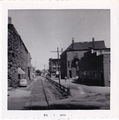
D.A.R. tracks crossing main street of Windsor on July 31, 1958.

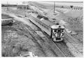
SW1200 with Caboose passing through downtown Windsor 1966.
Windsor Station awaiting demolition as the Highway 101 overpass is being built, July 1970.
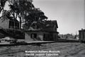
Windsor Station being demolished as tracks are ripped up for the Windsor Causeway realignment, July 1970.
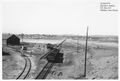
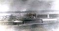
The Avon River Causeway, the new Windsor Station and new DAR main line all under construction at Windsor September 1970.
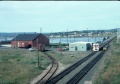
RDC 9058 or 9059 passing through Windsor, with the new Windsor Station and Avon River Causeway nearing completion October 11, 1970.
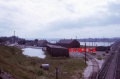
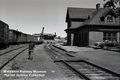
The new Windsor Station with the old freight shed in the centre and the L. A. Armstrong Apple Warehouse, Aug. 7, 1973.
Train No. 1 at Windsor Station with the L. A. Armstrong Apple Warehouse to the left and the Avon River Causeway to the right, Aug 17, 1977.
Windsor, with CPR Locomotive 8132 and freight train on the Avon River Causeway and a Southern Railroad boxcar parked at the L. A. Armstrong Apple Warehouse, Oct. 17, 1979.
Windsor Station in July 1993.
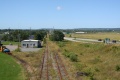
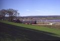
Windsor Station looking west down the Avon River Causeway on August 30, 2011.
The L. A. Armstrong Apple Warehouse in Windsor is demolished, November 19, 2019. Windsor's remaining apple warehouse, Dufferin Place (the old B. Sexton Apple Warehouse), seen in background.


.jpg)

References & Footnotes
- Alexander MacNab, Windsor and Annapolis Railway, Report of Alexander MacNab Nov 1, 1873
- 1969 Memorandum of General Information
- ↑ Dominion Atlantic Railway, 1969 Memorandum of General Information, page 3
Reference Tag
External Links
- Richard Manicom's photo story of Kentville freight Train No. 24 arriving in Windsor switching in the Windsor Railyard to make up the Truro mixed in 1974: Dominion Atlantic Railway Mixed Train Assembly Seen From the Cab Windsor Nova Scotia 1974