Dominion Atlantic Railway Digital Preservation Initiative - Wiki
Use of this site is subject to our Terms & Conditions.
Difference between revisions of "Windsor"
From DARwiki
Dan conlin (talk | contribs) (→Gallery: image) |
Dan conlin (talk | contribs) |
||
| Line 24: | Line 24: | ||
<gallery> | <gallery> | ||
Image:Avon River bridge curve.jpg|Eastern approach tracks to the [[Avon River Bridge]] from downtown [[Windsor]], in 1918, sharpest curve on the DAR. | Image:Avon River bridge curve.jpg|Eastern approach tracks to the [[Avon River Bridge]] from downtown [[Windsor]], in 1918, sharpest curve on the DAR. | ||
| − | + | File:DAR2516b.jpg|[[Train No. 95]] approaches Windsor, 1951. | |
File:Windsor_21_A16_East.jpg|Topographic map from Falmouth to Ellershouse circa 1956. | File:Windsor_21_A16_East.jpg|Topographic map from Falmouth to Ellershouse circa 1956. | ||
</gallery> | </gallery> | ||
Revision as of 20:32, 10 September 2012
Windsor, Nova Scotia
Mile 31.51 from Windsor Junction on the Halifax Subdivision (Mile 47.32 from Halifax)
Mile 0 Subdivision Truro
- Next Station East: Falmouth
- Next Station West: Dimock's
- Next Station South: Pembertons
Features
- Windsor Railyard
- Windsor Station
- Windsor Freight Shed
- Windsor Water Tower
- Windsor Wharves
- Avon River Bridge
History
Gallery

Eastern approach tracks to the Avon River Bridge from downtown Windsor, in 1918, sharpest curve on the DAR.
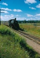
Train No. 95 approaches Windsor, 1951.
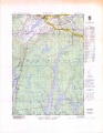
Topographic map from Falmouth to Ellershouse circa 1956.


References and Footnotes
External Links
- [http://www.gov.ns.ca/nsarm/virtual/NSIS/archives.asp?ID=282 Nova Scotia Archives, zoomable aerial view of Windsor and surrounding area.