Dominion Atlantic Railway Digital Preservation Initiative - Wiki
Use of this site is subject to our Terms & Conditions.
File:Torbrookwye.jpg
From DARwiki
No higher resolution available.
Torbrookwye.jpg (532 × 375 pixels, file size: 162 KB, MIME type: image/jpeg)
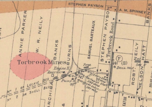
Detail of the terminus of the DAR Torbrook Mines spur from the geological map "Preliminary geological map of the Nictaux and Torbrook Iron District, Annapolis County, Nova Scotia"; Fletcher, H. Geological Survey of Canada, Multicoloured Geological Map 897, 1905
Original map: http://geoscan.nrcan.gc.ca/starweb/geoscan/servlet.starweb?path=geoscan/downloade.web&search1=R=107873
File history
Click on a date/time to view the file as it appeared at that time.
| Date/Time | Thumbnail | Dimensions | User | Comment | |
|---|---|---|---|---|---|
| current | 19:35, 21 February 2016 | | 532 × 375 (162 KB) | Dan conlin (talk | contribs) | Detail of the terminus of the DAR Torbrook Mines spur from the geological map "Preliminary geological map of the Nictaux and Torbrook Iron District, Annapolis County, Nova Scotia"; Fletcher, H. Geological Survey of Canada, Multicoloured Geological Map |
You cannot overwrite this file.
File usage
The following page uses this file: