Dominion Atlantic Railway Digital Preservation Initiative - Wiki
Use of this site is subject to our Terms & Conditions.
Category:Fire Insurance Maps
Fire Insurance Maps
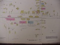
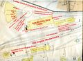
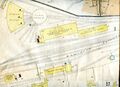
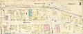
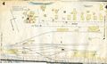
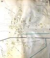
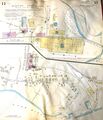
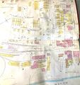
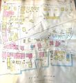
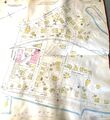
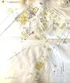
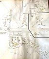
Fire insurance maps, also known as fire insurance plans, were used by insurance companies to evaluate risks for insured properties. They show things connected to fire risk with precision, like fire hydrants, building material and street access for fire trucks. They also recorded details like chimneys, boilers, window types and porches as well as many utilitarian structures often overlooked by other sources. Railway tracks are often shown in considerable detail, although the number of tracks and switch locations can be a bit approximate. Most towns in Nova Scotia had fire insurance maps from the late 1800s, updated regularly until the 1950s, but few have been digitized.
Note:For more precise details of tracks and sidings, see the DAR collection of Track Charts.
Media in category "Fire Insurance Maps"
The following 14 files are in this category, out of 14 total.
 1938 Berwick insurance map.JPG 1,600 × 1,200; 337 KB
 Canning Fire Insurance plan 1940 detail.jpg 4,608 × 3,456; 2.79 MB
 Kentville Fire Map 1921 Sheet 1 annotated.jpg 1,753 × 1,281; 1.63 MB
 Kentville Fire Map 1921 Sheet 1.jpg 1,753 × 1,273; 496 KB
 Kentville Fire Map 1921 Sheet 3.jpg 3,158 × 1,327; 1.42 MB
 Kentville Fire Map 1921 Sheet 4.jpg 2,048 × 1,229; 790 KB
 Windsor 1941 Sheet1.jpg 1,588 × 1,926; 863 KB
 Windsor 1941 Sheet10.jpg 1,515 × 1,752; 773 KB
 Windsor 1941 Sheet11.jpg 1,470 × 1,717; 809 KB
 Windsor 1941 Sheet2.jpg 1,632 × 1,733; 808 KB
 Windsor 1941 Sheet3.jpg 1,622 × 1,769; 949 KB
 Windsor 1941 Sheet4.jpg 1,633 × 1,786; 820 KB
 Windsor 1941 Sheet8.jpg 1,480 × 1,754; 808 KB
 Windsor 1941 Sheet9.jpg 1,521 × 1,800; 824 KB


