Dominion Atlantic Railway Digital Preservation Initiative - Wiki
Use of this site is subject to our Terms & Conditions.
Category:Bird's Eye Maps
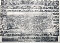
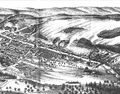
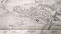
Bird's eye maps were a series of artistically-interpreted aerial map views of towns and cities published in the 19th century. Bird's eye views of DAR communities include the Bird's Eve View of Kentville Nova Scotia 1879, the Bird's Eve View of Windsor Nova Scotia 1878, the Bird's Eve View of Yarmouth Nova Scotia 1889 as well as bird's eyes of Digby, Truro and Halifax. While considerable artistic license was employed in scale and detail, they capture an impressive range of detail for railway facilities and customers in the early years of the railways that became the Dominion Atlantic.
External Links
Pages in category "Bird's Eye Maps"
The following 4 pages are in this category, out of 4 total.
Media in category "Bird's Eye Maps"
The following 4 files are in this category, out of 4 total.
 1878 Annapolis Royal & Granville NS.jpg 2,000 × 1,575; 471 KB
 200804527.jpg 3,111 × 2,233; 5.55 MB
 Birdseye.jpg 1,600 × 1,255; 2.21 MB
 NSA Windsor birdsyeye.jpg 1,600 × 910; 1.24 MB


