Dominion Atlantic Railway Digital Preservation Initiative - Wiki
Use of this site is subject to our Terms & Conditions.
File:201402101.jpg
From DARwiki
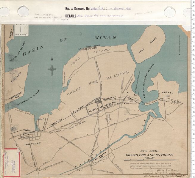
Revision as of 19:18, 11 July 2024 by Dan Conlin (talk | contribs) ("Grand Pre and Environs", map by the Dominion Atlantic Railway showing Wolfville, Grand Pre and Horton Landing and Acadian historical sites, 1920. Map was surveyed by Dominion Atlantic Railway engineers with historic sites identified by Placide Gaudet. Nova Scotia Archives Map Collection: V7 239 Grand Pre, Nova Scotia [https://archives.novascotia.ca/maps/archives/?ID=1381 Link to zoomable version on Nova Scotia Archives Website] [[Category:Nov...)

Size of this preview: 655 × 599 pixels. Other resolutions: 262 × 240 pixels | 1,670 × 1,528 pixels.
Original file (1,670 × 1,528 pixels, file size: 412 KB, MIME type: image/jpeg)
Summary
"Grand Pre and Environs", map by the Dominion Atlantic Railway showing Wolfville, Grand Pre and Horton Landing and Acadian historical sites, 1920.
Map was surveyed by Dominion Atlantic Railway engineers with historic sites identified by Placide Gaudet.
Nova Scotia Archives Map Collection: V7 239 Grand Pre, Nova Scotia Link to zoomable version on Nova Scotia Archives Website
File history
Click on a date/time to view the file as it appeared at that time.
| Date/Time | Thumbnail | Dimensions | User | Comment | |
|---|---|---|---|---|---|
| current | 19:18, 11 July 2024 | | 1,670 × 1,528 (412 KB) | Dan Conlin (talk | contribs) | "Grand Pre and Environs", map by the Dominion Atlantic Railway showing Wolfville, Grand Pre and Horton Landing and Acadian historical sites, 1920. Map was surveyed by Dominion Atlantic Railway engineers with historic sites identified by Placide Gaudet. Nova Scotia Archives Map Collection: V7 239 Grand Pre, Nova Scotia [https://archives.novascotia.ca/maps/archives/?ID=1381 Link to zoomable version on Nova Scotia Archives Website] [[Category:Nov... |
You cannot overwrite this file.
File usage
The following 4 pages use this file: