Dominion Atlantic Railway Digital Preservation Initiative - Wiki
Use of this site is subject to our Terms & Conditions.
Difference between revisions of "Clementsport"
Dan Conlin (talk | contribs) m (→Gallery) |
Dan Conlin (talk | contribs) |
||
| Line 19: | Line 19: | ||
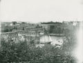
File:201580067.jpg|Clementsport and the [[Clementsport Bridge]] open for an inbound schooner, circa 1895. | File:201580067.jpg|Clementsport and the [[Clementsport Bridge]] open for an inbound schooner, circa 1895. | ||
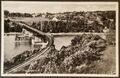
Image:ClementsportBridgeb.jpg|[[Clementsport Bridge]] and wharves, circa 1900. | Image:ClementsportBridgeb.jpg|[[Clementsport Bridge]] and wharves, circa 1900. | ||
| + | File:Kalkman108.jpg|A postcard showing an eastbound passenger train crossing the [[Clementsport Bridge]], Oct. 18, 1905. | ||
File:ClementsportBridge1941A1.jpg|The [[Clementsport Bridge]] with the village of the [[Clementsport]] in the background, circa 1940. | File:ClementsportBridge1941A1.jpg|The [[Clementsport Bridge]] with the village of the [[Clementsport]] in the background, circa 1940. | ||
File:13321.jpg|[[Clementsport]] and the [[Clementsport Bridge]], air photo by the Nova Scotia Information Service, 1950s. | File:13321.jpg|[[Clementsport]] and the [[Clementsport Bridge]], air photo by the Nova Scotia Information Service, 1950s. | ||
Revision as of 21:13, 2 August 2024
Clementsport, Nova Scotia
- Subdivision Yarmouth, Mile 7.40
- Elevation unknown
- Passing track 1267' long (1969).
- Next Station East: Upper Clements
- Next Station West: Cornwallis
Feature and Facilities
- 90 foot pile trestle over public road and small brook, Mile 7.14
- Clementsport Station, Mile 7.4, Scheduled stop from 1894 to 1990
- Overhead timber bridge carrying public road, Mile 7.51
- Clementsport Bridge, over Moose River, Mile 7.67
Gallery
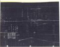
CPR Track chart showing track profile of Clementsport and the Clementsport Bridge, Mar. 18, 1918.
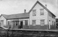
First Clementsport Station, circa 1905.
Clementsport and the Clementsport Bridge open for an inbound schooner, circa 1895.
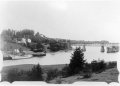
Clementsport Bridge and wharves, circa 1900.
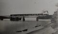
A postcard showing an eastbound passenger train crossing the Clementsport Bridge, Oct. 18, 1905.
The Clementsport Bridge with the village of the Clementsport in the background, circa 1940.
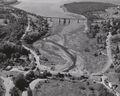
Clementsport and the Clementsport Bridge, air photo by the Nova Scotia Information Service, 1950s.
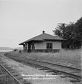
Second Clementsport Station, east end with siding and level crossing in foreground, July 1959.

A snowbound RDC at Clementsport, 1970.

RDC No. 9062 crossing the pile trestle at Mile 7.1 just east of Clementsport, Sept. 24, 1976.

VIA Rail poster for The Evangeline "Dayliner" with a westbound RDC on the Clementsport Bridge, circa 1985.


References
Memorandum of General Information on the Dominion Atlantic Railway, Feb. 17, 1969, page 15, Dominion Atlantic Railway, Library and Archives Canada HE2810 D7 D7 fol.