Dominion Atlantic Railway Digital Preservation Initiative - Wiki
Use of this site is subject to our Terms & Conditions.
Difference between revisions of "Annapolis Royal Bridge"
Dan Conlin (talk | contribs) (→Gallery: plan specs) |
Dan Conlin (talk | contribs) m (→Gallery) |
||
| Line 10: | Line 10: | ||
<gallery> | <gallery> | ||
| − | File: | + | File:CSTM-STR-03987b.jpeg|[[DAR0018|DAR Engine No. 18]] with a passenger train on the [[Annapolis Royal Bridge]] with the [[Annapolis_Royal_Station#Third_.22Frogmore.22_Station_c._1891_to_1914|Annapolis Royal "Frogmore" station]] on far right, 1909. |
File:Frogmorewithtrain.jpg|Postcard of a westbound passenger train at the [[Annapolis Royal Station]] with the [[Annapolis Royal Bridge]] in background, taken from the [[St. George Street Overpass]] looking west, circa 1910. | File:Frogmorewithtrain.jpg|Postcard of a westbound passenger train at the [[Annapolis Royal Station]] with the [[Annapolis Royal Bridge]] in background, taken from the [[St. George Street Overpass]] looking west, circa 1910. | ||
Revision as of 19:51, 24 June 2024
Annapolis Royal Bridge
Mile 00.27 on the Yarmouth Subdivision[1]
This bridge crossed the the wide, tidal Allen's Creek (also know as the Allain River), just west of Annapolis Royal. It was originally built as a wooden bridge, 325 feet long exclusive of the wooden approaches. It was replaced by a new bridge in 1914. The substructure consisted of 2 piers and two abutments, all of concrete, and the superstructure was one 150 foot Through Truss span and two 85 foot Through Plate Girder spans with standard wooden trestle approaches at both ends.[2] The length of all spans totaled 468 feet in 1968.[3]
The 1914 structure remained essentially the same until the line west of Coldbrook was abandoned in March 1990. The bridge remains intact but heavily weathered as of 2020 with gaps dug at approaches to discourage recreational use.
Gallery
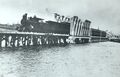
DAR Engine No. 18 with a passenger train on the Annapolis Royal Bridge with the Annapolis Royal "Frogmore" station on far right, 1909.
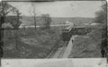
Postcard of a westbound passenger train at the Annapolis Royal Station with the Annapolis Royal Bridge in background, taken from the St. George Street Overpass looking west, circa 1910.
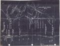
Track Schematic for Annapolis Royal showing the wye, sidings and specs for the Annapolis Royal Bridge, circa 1918.

Annapolis Royal Bridge on August 5, 1973.
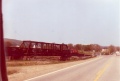
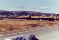
Eastbound freight crosses the Annapolis Royal Bridge approaching Annapolis Royal. May 18, 1989.
The Burro Crane working on the Allain River Bridge, 1989.

The bridge from Fort Anne, circa 1990.
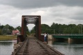
The Annapolis Royal Bridge looking east to the town of Annapolis Royal, September 9, 2005.

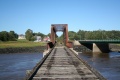
The Annapolis Royal Bridge crossing the Allain River, August 30, 2011.
A track view of the Annapolis Royal Bridge crossing the Allain River, facing east on August 30, 2011.
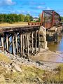
West end of the bridge, 2019.


.jpg)
.jpg)

References
- ↑ Dominion Atlantic Railway, 1969 Memorandum of General Information, p. 15.
- ↑ Extensive Improvements on the Dominion Atlantic Railway.” CANADIAN RAILWAY AND MARINE WORLD, November 1914, 490.|Extensive Improvements on the Dominion Atlantic Railway.” CANADIAN RAILWAY AND MARINE WORLD, November 1914, p. 490.
- ↑ Dominion Atlantic Railway, 1969 Memorandum of General Information, p. 15.