Dominion Atlantic Railway Digital Preservation Initiative - Wiki
Use of this site is subject to our Terms & Conditions.
Difference between revisions of "Mochelle"
From DARwiki
Dan Conlin (talk | contribs) (Created page with "=Mochelle, Nova Scotia= Subdivision Kentville, Mile 55.4 Elevation: 32 feet *Next Station East: Round Hill *Next Station West: Anna...") |
Dan Conlin (talk | contribs) (images) |
||
| Line 10: | Line 10: | ||
* Flag Stop Station | * Flag Stop Station | ||
* No siding | * No siding | ||
| − | * 15 foot pile trestle over Howe Creek at Mile 56<ref>*[[1969-MemoOfGenInfo|1969 Memorandum of General Information]]</ref> | + | * 15 foot pile trestle over Howe Creek at Mile 56.7<ref>*[[1969-MemoOfGenInfo|1969 Memorandum of General Information, p. 13]]</ref> |
==Description & History== | ==Description & History== | ||
| Line 17: | Line 17: | ||
==Gallery== | ==Gallery== | ||
<Gallery perrow=5> | <Gallery perrow=5> | ||
| − | + | File:R-108 edited.jpg |Transferring passengers and mail from wreck of [[Train No. 95]], at [[Mochelle]], near [[Annapolis Royal]], January 25, 1921. | |
| + | File:R-109 edited.jpg |Transferring baggage from wreck of [[Train No. 95]], at [[Mochelle]], near [[Annapolis Royal]], January 25, 1921. | ||
</gallery> | </gallery> | ||
Revision as of 11:24, 10 December 2023
Mochelle, Nova Scotia
Subdivision Kentville, Mile 55.4
Elevation: 32 feet
- Next Station East: Round Hill
- Next Station West: Annapolis Royal
Facilities & Features
- Flag Stop Station
- No siding
- 15 foot pile trestle over Howe Creek at Mile 56.7[1]
Description & History
This small community of about 177 people half way between Annapolis Royal and Round Hill was named after and early French settler.[2] It was the scene of a major passenger train derailment in 1921.
Gallery
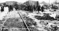
Transferring passengers and mail from wreck of Train No. 95, at Mochelle, near Annapolis Royal, January 25, 1921.
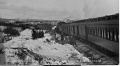
Transferring baggage from wreck of Train No. 95, at Mochelle, near Annapolis Royal, January 25, 1921.

