Dominion Atlantic Railway Digital Preservation Initiative - Wiki
Use of this site is subject to our Terms & Conditions.
Difference between revisions of "Bear River"
Dan conlin (talk | contribs) m (→Gallery) |
Dan conlin (talk | contribs) (→Gallery: link) |
||
| Line 17: | Line 17: | ||
Image:1903-LANDOFEVANGELINE-P19.jpg|Bear River circa 1890s. | Image:1903-LANDOFEVANGELINE-P19.jpg|Bear River circa 1890s. | ||
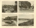
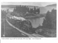
Image:BearRiverBridged.jpg|Bear River station area to west of [[Bear River Bridge]] with [[Flying Bluenose]], [[Train No. 124]], circa 1906. | Image:BearRiverBridged.jpg|Bear River station area to west of [[Bear River Bridge]] with [[Flying Bluenose]], [[Train No. 124]], circa 1906. | ||
| − | File:CSTM-STR04099a 001 aa cs.jpg | 1906 | + | File:CSTM-STR04099a 001 aa cs.jpg |[[Bear River Bridge]], looking east, 1906 |
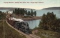
File:FlyingBluenoseGoatIsland.jpg|Colour postcard of the [[Flying Bluenose]] entering the Bear River Curve. | File:FlyingBluenoseGoatIsland.jpg|Colour postcard of the [[Flying Bluenose]] entering the Bear River Curve. | ||
Image:FlyingBluenoseBearRiver.jpg|Colour postcard of the [[Flying Bluenose]] at the Bear River Curve. | Image:FlyingBluenoseBearRiver.jpg|Colour postcard of the [[Flying Bluenose]] at the Bear River Curve. | ||
Revision as of 19:13, 13 October 2020
Bear River, Nova Scotia
- Subdivision Yarmouth, Mile 13.6
- Elevation 42'
- Passing Track 914' long at station.
Bear River had a large wooden passenger and freight station built to Intercolonial Railway plans by the federal government when they constructed the missing link between Annapolis Royal and Digby including the massive Bear River Bridge, a mile east of the station.
Features & Facilities
Gallery

Track Schematic for Bear River.
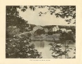
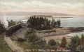
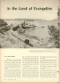
Bear River circa 1890s.
Bear River circa 1890s.
Bear River station area to west of Bear River Bridge with Flying Bluenose, Train No. 124, circa 1906.
Bear River Bridge, looking east, 1906
Colour postcard of the Flying Bluenose entering the Bear River Curve.
Colour postcard of the Flying Bluenose at the Bear River Curve.
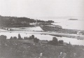
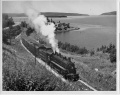
DAR train at the Bear River Curve, circa 1900.
No. 2528 eastbound at the Bear River Curve, circa 1950.
Train No. 95 at the Bear River curve in "Trains" magazine, 1951.

Bear River Curve 1973.

Bear River curve from the trailing cab of an RDC, June 13, 1979.
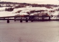
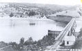
No. 1272 gently eases across the Bear River Bridge in the winter of 1988.
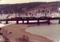
No. 1272 makes its way East across the Bear River Bridge in the winter of 1988.
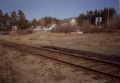
Bear River VIA Rail stop. April 1986.
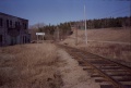
Bear River, looking railway East. April 1986.
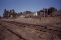
Bear River VIA Rail stop. April 1986.
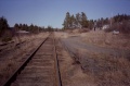
Bear River VIA Rail stop. April 1986.

Bear River VIA Rail stop. April 1986.


References
Memorandum of General Information on the Dominion Atlantic Railway, Feb. 17, 1969, page 16, Dominion Atlantic Railway, Library and Archives Canada HE2810 D7 D7 fol.