Dominion Atlantic Railway Digital Preservation Initiative - Wiki
Use of this site is subject to our Terms & Conditions.
Difference between revisions of "Hartville"
From DARwiki
Dan conlin (talk | contribs) |
m |
||
| Line 18: | Line 18: | ||
==Gallery== | ==Gallery== | ||
<Gallery perrow=5> | <Gallery perrow=5> | ||
| + | File:HA-24.58 Hartville.jpg|1918 Track Chart of Hartville | ||
File:Windsor_21_A16_East.jpg|Topographic map from Falmouth to Ellershouse circa 1956. | File:Windsor_21_A16_East.jpg|Topographic map from Falmouth to Ellershouse circa 1956. | ||
</Gallery> | </Gallery> | ||
| Line 33: | Line 34: | ||
[[Category:Locations]] | [[Category:Locations]] | ||
| − | [[Category:Subdivision Halifax| | + | [[Category:Subdivision Halifax|HA-24.58]] |
Revision as of 11:45, 27 February 2020
Hartville, Nova Scotia
Mile 24.52 from Windsor Junction on the Halifax Subdivision (Mile 40.33 from Halifax)
- Next Station East: Ellershouse
- Next Station West: Newport
Facilities & Features
Hartville Bridge, across the St. Croix River.
Commerce & Industry
Description & History
Operations & Orders
Gallery
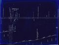
1918 Track Chart of Hartville
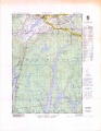
Topographic map from Falmouth to Ellershouse circa 1956.

