Dominion Atlantic Railway Digital Preservation Initiative - Wiki
Use of this site is subject to our Terms & Conditions.
Difference between revisions of "Green Oaks"
From DARwiki
Dan conlin (talk | contribs) (→Gallery: image) |
|||
| Line 20: | Line 20: | ||
==Gallery== | ==Gallery== | ||
<Gallery> | <Gallery> | ||
| + | File:DAR - Shubenacadie Bridge East Bank - Unknown Photographer - 2May1987.JPG |The [[South Maitland Bridge]], seen from east bank of the river at [[Green Oaks]], May 2, 1987. | ||
</Gallery> | </Gallery> | ||
| Line 25: | Line 26: | ||
For References, please list general references first. Leave the "cite" wiki markup in at the end and use the cite "<ref> and </ref> right in the text to footnote specific items. The Memorandum reference should be left unless the location or structures listed do not show up in the memorandum. | For References, please list general references first. Leave the "cite" wiki markup in at the end and use the cite "<ref> and </ref> right in the text to footnote specific items. The Memorandum reference should be left unless the location or structures listed do not show up in the memorandum. | ||
--> | --> | ||
| + | |||
==References & Footnotes== | ==References & Footnotes== | ||
*[[1969-MemoOfGenInfo|1969 Memorandum of General Information]] | *[[1969-MemoOfGenInfo|1969 Memorandum of General Information]] | ||
Latest revision as of 16:37, 2 December 2018
Green Oaks, Nova Scotia
Subdivision Truro, Mile 42.04
Next Station East: Princeport Road
Next Station West: South Maitland
Facilities & Features
Description & History
Operations & Orders
Gallery
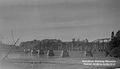
The South Maitland Bridge, seen from east bank of the river at Green Oaks, May 2, 1987.
