Dominion Atlantic Railway Digital Preservation Initiative - Wiki
Use of this site is subject to our Terms & Conditions.
Difference between revisions of "Kentville Cornwallis River Spillway Bridge"
From DARwiki
Dan conlin (talk | contribs) (image) |
Dan conlin (talk | contribs) (→Gallery: image) |
||
| Line 12: | Line 12: | ||
==Gallery== | ==Gallery== | ||
<gallery> | <gallery> | ||
| + | File:2008.002.85medres.jpg|The [[Canada Foods Plant]] with the [[Kentville Roundhouse]], plus the [[Kentville Water Tower]], the [[Kentville Cornwallis River Bridge]] in the centre and the [[Kentville Cornwallis River Spillway Bridge|Spillway Trestle]] to the left, 1949. | ||
Image:CPR8131 Kingsport Way Freight 1961.jpg|[[CPR8131|CPR No. 8131]] crossing the Spillway Bridge with the [[Kingsport]] Way Freight in the last days of branchline, August 1959 | Image:CPR8131 Kingsport Way Freight 1961.jpg|[[CPR8131|CPR No. 8131]] crossing the Spillway Bridge with the [[Kingsport]] Way Freight in the last days of branchline, August 1959 | ||
</gallery> | </gallery> | ||
Revision as of 16:04, 16 October 2017
Kentville Cornwallis River Spillway Bridge
- Spur Track D Kingsport, Mile 0.27
- Subdivision Kingsport, Mile 0.27
A 45 foot four bent pile trestle just to the north of the Kentville Cornwallis River Bridge at mile .27 that acts as a spillway to relieve pressure on the main bridge during floods.(1)
References
(1) Bridge specs from CPR Trackplan of Kentville Railyard
Gallery
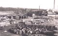
The Canada Foods Plant with the Kentville Roundhouse, plus the Kentville Water Tower, the Kentville Cornwallis River Bridge in the centre and the Spillway Trestle to the left, 1949.
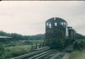
CPR No. 8131 crossing the Spillway Bridge with the Kingsport Way Freight in the last days of branchline, August 1959

