Dominion Atlantic Railway Digital Preservation Initiative - Wiki
Use of this site is subject to our Terms & Conditions.
Difference between revisions of "Canning Bridge"
From DARwiki
Dan conlin (talk | contribs) (Created page with "==Canning Bridge== *Subdivision Kingsport, Mile 10.3 ---- Small pile trestle bridge over brook just east of Canning, about Mile 10.3 * ...") |
Dan conlin (talk | contribs) (image) |
||
| Line 4: | Line 4: | ||
---- | ---- | ||
| − | Small pile trestle bridge over brook just east of [[Canning]], about Mile 10.3 | + | Small pile trestle bridge over small brook and marsh just east of [[Canning]], about Mile 10.3 |
* Three pile trestle bents | * Three pile trestle bents | ||
==History== | ==History== | ||
| − | This small trestle was visible from Highway 221 and served as the subject of several photographs of DAR trains arriving at Canning. Sometime after the CVR was abandoned in 1961 the bridge was filled in to create a dam for a dockpond to the north of the bridge | + | This small trestle was visible from Highway 221 and served as the subject of several photographs of DAR trains arriving at Canning. Sometime after the CVR was abandoned in 1961 the bridge was filled in to create a dam for a dockpond to the north of the bridge embankment. |
==Gallery== | ==Gallery== | ||
<Gallery> | <Gallery> | ||
| + | File:Canningbridgesouth.JPG|Location of bridge in rail embankment to left, April 2008. | ||
</Gallery> | </Gallery> | ||
Latest revision as of 15:36, 8 November 2013
Canning Bridge
- Subdivision Kingsport, Mile 10.3
Small pile trestle bridge over small brook and marsh just east of Canning, about Mile 10.3
- Three pile trestle bents
History
This small trestle was visible from Highway 221 and served as the subject of several photographs of DAR trains arriving at Canning. Sometime after the CVR was abandoned in 1961 the bridge was filled in to create a dam for a dockpond to the north of the bridge embankment.
Gallery
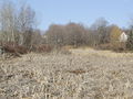
Location of bridge in rail embankment to left, April 2008.

References and Footnotes
Dan Conlin Field notes CVR Trip, April 20, 2008