Dominion Atlantic Railway Digital Preservation Initiative - Wiki
Use of this site is subject to our Terms & Conditions.
Difference between revisions of "Horton Landing"
From DARwiki
Dan conlin (talk | contribs) |
Samuelmclark (talk | contribs) |
||
| Line 15: | Line 15: | ||
File:Wolfville 1905 Snowstorm a.jpg|Horton tracks and snow canyon during the famous winter of 1905. | File:Wolfville 1905 Snowstorm a.jpg|Horton tracks and snow canyon during the famous winter of 1905. | ||
Image:Hortonlanding.jpg|Horton Landing Station, circa 1950. | Image:Hortonlanding.jpg|Horton Landing Station, circa 1950. | ||
| + | File:HortonLandingsStation_-_1957July.png|Horton Landing Station 1957 July | ||
File:Wolfville_21_H1_West.jpg|Topographic map from Kentville to Hortons Landing circa 1956. | File:Wolfville_21_H1_West.jpg|Topographic map from Kentville to Hortons Landing circa 1956. | ||
</Gallery> | </Gallery> | ||
Revision as of 09:26, 26 April 2013
Horton Landing, Nova Scotia
Mile 45.34 from Windsor Junction on the Halifax Subdivision (Mile 61.15 from Halifax)
The Horton Landing station was on the west bank of the Gaspereaux River, not far from the Gaspereaux River Bridge.
Facilities
- Horton Station
- 1472 feet long Passing track in 1969
Gallery
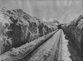
Horton tracks and snow canyon during the famous winter of 1905.
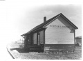
Horton Landing Station, circa 1950.
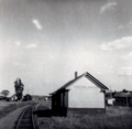
Horton Landing Station 1957 July
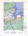
Topographic map from Kentville to Hortons Landing circa 1956.


