Dominion Atlantic Railway Digital Preservation Initiative - Wiki
Use of this site is subject to our Terms & Conditions.
Difference between revisions of "Avonport"
From DARwiki
| Line 2: | Line 2: | ||
*[[:Category:Subdivision Halifax|Halifax Subdivision]] (from [[Windsor Junction]]), Mile 43.45, (from [[Halifax]]), Mile 59.26 | *[[:Category:Subdivision Halifax|Halifax Subdivision]] (from [[Windsor Junction]]), Mile 43.45, (from [[Halifax]]), Mile 59.26 | ||
<Gallery> | <Gallery> | ||
| − | |||
| − | |||
Image:Gaspereaux River Bridge a.jpg|The [[Gaspereaux River Bridge]] looking east over the Gaspereaux River at [[Horton Landing|Hortonville]] with [[Avonport]] in the distance. | Image:Gaspereaux River Bridge a.jpg|The [[Gaspereaux River Bridge]] looking east over the Gaspereaux River at [[Horton Landing|Hortonville]] with [[Avonport]] in the distance. | ||
| + | File:Wolfville_21_H1_West.jpg|Topographic map from Avonport to Shaws Bog circa 1956. | ||
</Gallery> | </Gallery> | ||
[[Category:Locations]] | [[Category:Locations]] | ||
[[Category:Subdivision Halifax|165]] | [[Category:Subdivision Halifax|165]] | ||
Revision as of 14:13, 13 January 2012
Avonport, Nova Scotia
- Halifax Subdivision (from Windsor Junction), Mile 43.45, (from Halifax), Mile 59.26
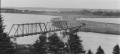
The Gaspereaux River Bridge looking east over the Gaspereaux River at Hortonville with Avonport in the distance.
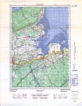
Topographic map from Avonport to Shaws Bog circa 1956.

