Dominion Atlantic Railway Digital Preservation Initiative - Wiki
Use of this site is subject to our Terms & Conditions.
Difference between revisions of "Groves"
From DARwiki
Dan Conlin (talk | contribs) |
Dan Conlin (talk | contribs) m |
||
| Line 1: | Line 1: | ||
__NOTITLE__ __NOTOC__ | __NOTITLE__ __NOTOC__ | ||
| − | =Groves= | + | =Groves Siding= |
Mile 8.56 from [[Windsor Junction]] on the [[:Category:Subdivision Halifax|Halifax Subdivision]] (Mile 24.6 from [[Halifax]]) | Mile 8.56 from [[Windsor Junction]] on the [[:Category:Subdivision Halifax|Halifax Subdivision]] (Mile 24.6 from [[Halifax]]) | ||
| Line 16: | Line 16: | ||
==Commerce & Industry== | ==Commerce & Industry== | ||
| − | Groves was the location of a quarry. | + | Groves was also the location of a quarry. |
==Gallery== | ==Gallery== | ||
Revision as of 08:17, 26 May 2022
Groves Siding
Mile 8.56 from Windsor Junction on the Halifax Subdivision (Mile 24.6 from Halifax)
Elevation: 456 feet
- Next Station East: Fenerty's
- Next Station West: South Uniacke
Facilities & Features
- Siding. 1620 feet long. Capacity: 28 cars.
Description & History
The siding was likely named after the Groves family based in Beaver Bank who operated a variety of enterprises including box making, brick making, farming, saw milling and ran a boarding school.[1]
Commerce & Industry
Groves was also the location of a quarry.
Gallery
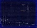
1918 Track Chart of Groves
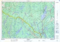
Topographic map from Stillwater to Windsor Junction circa 1956.

