Dominion Atlantic Railway Digital Preservation Initiative - Wiki
Use of this site is subject to our Terms & Conditions.
Difference between revisions of "Brooklyn"
From DARwiki
Dan conlin (talk | contribs) (→Gallery: image) |
Dan conlin (talk | contribs) (→Gallery: links) |
||
| Line 22: | Line 22: | ||
File:Quarries.jpg|[[:Category:Gypsum_Trains|gypsum quarry]] spurs in the [[Windsor]], [[Dimock's]], [[Brooklyn]] and [[Newport]] areas, from geological map, 1909. | File:Quarries.jpg|[[:Category:Gypsum_Trains|gypsum quarry]] spurs in the [[Windsor]], [[Dimock's]], [[Brooklyn]] and [[Newport]] areas, from geological map, 1909. | ||
File:Wolfville_21_H1_East.jpg|Topographic map from Avonport to Shaws Bog circa 1956. | File:Wolfville_21_H1_East.jpg|Topographic map from Avonport to Shaws Bog circa 1956. | ||
| + | File:BrooklynStation_-_1958July.png|[[Brookyn Station]] 1958 July Looking Westbound. | ||
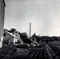
| + | Image:Brooklyn Station.jpg|Dominion Atlantic Station at [[Brooklyn]] on August 1, 1958. | ||
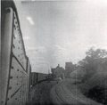
| + | Image:Brooklyn, NS from engine 2627 on Train 22 8-1-58.jpg|[[Brooklyn Stationt]] as seen from engine [[DAR2627|No. 2627]] leading [[Train No. 22]] on August 1, 1958. | ||
| + | File:BrooklynStation_-_1958August.png|[[Brooklyn Station]] 1958 August | ||
| + | Image:Brooklyn Station 1967.jpg|[[Brooklyn Station]], Hants County, NS. on July 20, 1967. | ||
</Gallery> | </Gallery> | ||
Revision as of 20:49, 16 November 2018
Brooklyn, Hants County, Nova Scotia
Subdivision Truro, Mile 6.18
Next Station West: Scotch Village
Next Station East: Mantua
Facilities & Features
Description & History
Operations & Orders
Gallery
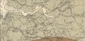
gypsum quarry spurs in the Windsor, Dimock's, Brooklyn and Newport areas, from geological map, 1909.

Topographic map from Avonport to Shaws Bog circa 1956.
Brookyn Station 1958 July Looking Westbound.

Dominion Atlantic Station at Brooklyn on August 1, 1958.

Brooklyn Stationt as seen from engine No. 2627 leading Train No. 22 on August 1, 1958.
Brooklyn Station 1958 August

Brooklyn Station, Hants County, NS. on July 20, 1967.


