Dominion Atlantic Railway Digital Preservation Initiative - Wiki
Use of this site is subject to our Terms & Conditions.
Difference between revisions of "South Maitland"
Dan conlin (talk | contribs) (→External Links: interp centre) |
Dan conlin (talk | contribs) |
||
| Line 36: | Line 36: | ||
For References, please list general references first. Leave the "cite" wiki markup in at the end and use the cite "<ref> and </ref> right in the text to footnote specific items. The Memorandum reference should be left unless the location or structures listed do not show up in the memorandum. | For References, please list general references first. Leave the "cite" wiki markup in at the end and use the cite "<ref> and </ref> right in the text to footnote specific items. The Memorandum reference should be left unless the location or structures listed do not show up in the memorandum. | ||
--> | --> | ||
| − | |||
==References & Footnotes== | ==References & Footnotes== | ||
*[[1969-MemoOfGenInfo|1969 Memorandum of General Information, page 22]] | *[[1969-MemoOfGenInfo|1969 Memorandum of General Information, page 22]] | ||
| − | <references /> | + | <references/> |
==External Links== | ==External Links== | ||
Revision as of 19:51, 24 May 2013
South Maitland, Nova Scotia
Truro Subdivision, the Midland Line, Mile 40.27
- Next Station East: Green Oaks
- Next Station West: Burtons
Facilities & Features
- South Maitland Station
- South Maitland Water Tower
- South Maitland Bridge
- 1316 foot passing siding
Description & History
This village on the Shubenacadie River was once a major shipbuilding and timber community as well as home to gypsum quarries. It became an important stop on the Midland Line with substancial station, water tower and most notably, the large swing bridge over the Shubenacadie River. In 2006 the Fundy Tidal Interpretation Centre opened at South Maitland beside the old DAR roadbed. The centre includes a caboose with retro DAR lettering and a hiking trail that leads to a lookoff on one of the piers of the DAR's old South Maitland Bridge.
Operations & Orders
Gallery
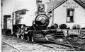
No. 29 "Brooklyn" at South Maitland Station.

Train No. 22 near South Maitland on August 1, 1958

South Maitland Station taken from rear of Train No. 22 on August 1, 1958.

The South Maitland Bridge under construction, circa 1900.
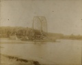
A truss span arrives at the South Maitland Bridge, circa 1900.

A truss span moves into place at the South Maitland Bridge, circa 1900.

South Maitland Bridge over the Schubenacadie River near South Maitland on August 1, 1958.
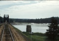
South Maitland Bridge over the Schubenacadie River, near South Maitland from the rear of Train No. 22 on August 1, 1958.


References & Footnotes
External Links
Tidal Interpretive Centre at South Maitland