Dominion Atlantic Railway Digital Preservation Initiative - Wiki
Use of this site is subject to our Terms & Conditions.
Difference between revisions of "Truro Station"
| Line 4: | Line 4: | ||
The station still remains standing and in use, as seen from this [http://maps.google.ca/maps?q=Truro+NS&hl=en&ll=45.358056,-63.292118&spn=0.004968,0.012853&sll=45.177896,-63.721297&sspn=0.019936,0.051413&t=h&hnear=Truro,+Colchester+County,+Nova+Scotia&z=17&layer=c&cbll=45.358741,-63.291331&panoid=wIPEf_dd1Ovodk6_eHAFvw&cbp=12,273.43,,3,1.71 Google Street View] | The station still remains standing and in use, as seen from this [http://maps.google.ca/maps?q=Truro+NS&hl=en&ll=45.358056,-63.292118&spn=0.004968,0.012853&sll=45.177896,-63.721297&sspn=0.019936,0.051413&t=h&hnear=Truro,+Colchester+County,+Nova+Scotia&z=17&layer=c&cbll=45.358741,-63.291331&panoid=wIPEf_dd1Ovodk6_eHAFvw&cbp=12,273.43,,3,1.71 Google Street View] | ||
| + | |||
| + | In an email dated January 9, 2012, [[:Category:Andrew Blackburn|Andrew Backburn]] reports that "The Town of Truro Parks and Rec. dept have taken over the building for about 2 years now. The Station yard has been made smaller as the Town covered some of the track area and some of the parking lot with soil and seeded grass. The trail starts in this area also although it still goes up and meets the CN main line." | ||
==Gallery== | ==Gallery== | ||
Revision as of 10:33, 10 January 2013
Truro Station
According to the caption on a photo, this station was built in 1959.
The station still remains standing and in use, as seen from this Google Street View
In an email dated January 9, 2012, Andrew Backburn reports that "The Town of Truro Parks and Rec. dept have taken over the building for about 2 years now. The Station yard has been made smaller as the Town covered some of the track area and some of the parking lot with soil and seeded grass. The trail starts in this area also although it still goes up and meets the CN main line."
Gallery
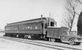
Crew car No. 411503 being used as a station while the new station was being built at Truro in 1959.
June 1974.
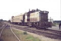
Midland division train at Truro Station, Truro in July 1975.
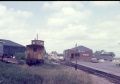
CP Caboose No. 437131 at Truro on July 21, 1975.
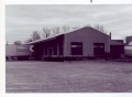
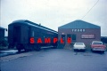
Truro Station. Undated photo.


