Dominion Atlantic Railway Digital Preservation Initiative - Wiki
Use of this site is subject to our Terms & Conditions.
Difference between revisions of "Cornwallis"
From DARwiki
| Line 14: | Line 14: | ||
==Gallery== | ==Gallery== | ||
<Gallery> | <Gallery> | ||
| − | |||
| − | |||
| − | |||
Image:IMG 2718.JPG | Image:IMG 2718.JPG | ||
Image:IMG 2722.JPG | Image:IMG 2722.JPG | ||
| Line 22: | Line 19: | ||
Image:IMG 2725.JPG | Image:IMG 2725.JPG | ||
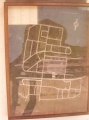
Image:DARCornwallisStationMap'80.jpg|CFS Cornwallis Station map 1980. | Image:DARCornwallisStationMap'80.jpg|CFS Cornwallis Station map 1980. | ||
| − | |||
| − | |||
| − | |||
| − | |||
</Gallery> | </Gallery> | ||
[[Category:Locations]] | [[Category:Locations]] | ||
[[Category:Subdivision Yarmouth|Y089]] | [[Category:Subdivision Yarmouth|Y089]] | ||
Revision as of 17:33, 10 October 2010
Cornwallis, Nova Scotia
- Subdivision Yarmouth, Mile 8.9
- Elevation 65'
- 1478' trackage to serve base heating plant (1969).
- Passing track 1356' long.
Features and Facilities
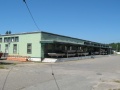
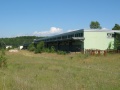
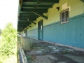
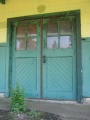
Gallery
CFS Cornwallis Station map 1980.


