Dominion Atlantic Railway Digital Preservation Initiative - Wiki
Use of this site is subject to our Terms & Conditions.
Difference between revisions of "Cornwallis"
From DARwiki
| Line 16: | Line 16: | ||
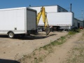
Image:IMG 2724.JPG | Image:IMG 2724.JPG | ||
Image:IMG 2725.JPG | Image:IMG 2725.JPG | ||
| − | Image:DARCornwallisStationMap'80.jpg|CFS Cornwallis Station map 1980.Image:DARCornwallisStationEastSide'80.jpg|CFS [[Cornwallis Station]], east side, 1980. | + | Image:DARCornwallisStationMap'80.jpg|CFS Cornwallis Station map 1980. |
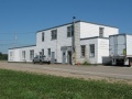
| + | Image:DARCornwallisStationEastSide'80.jpg|CFS [[Cornwallis Station]], east side, 1980. | ||
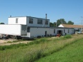
Image:DARCornwallisStationNorthSide'80.jpg|CFS [[Cornwallis Station]], north side, 1980. | Image:DARCornwallisStationNorthSide'80.jpg|CFS [[Cornwallis Station]], north side, 1980. | ||
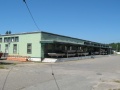
Image:DARCornwallisStationSouthSide'80.jpg|CFS [[Cornwallis Station]], south side, 1980. | Image:DARCornwallisStationSouthSide'80.jpg|CFS [[Cornwallis Station]], south side, 1980. | ||
Revision as of 17:28, 10 October 2010
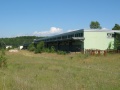
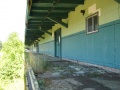
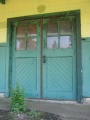
Cornwallis, Nova Scotia
- Subdivision Yarmouth, Mile 8.9
- Elevation 65'
- 1478' trackage to serve base heating plant (1969).
- Passing track 1356' long.
Features and Facilities
Gallery
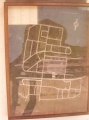
CFS Cornwallis Station map 1980.
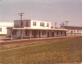
CFS Cornwallis Station, east side, 1980.
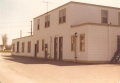
CFS Cornwallis Station, north side, 1980.
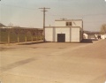
CFS Cornwallis Station, south side, 1980.
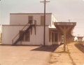
CFS Cornwallis Station, west side, 1980.


