Dominion Atlantic Railway Digital Preservation Initiative - Wiki
Use of this site is subject to our Terms & Conditions.
Difference between revisions of "Bear River Bridge"
| Line 28: | Line 28: | ||
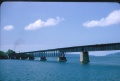
Image:Bear River Bridge.jpg|Taken from east end looking west -Hwy. 101 on the left. | Image:Bear River Bridge.jpg|Taken from east end looking west -Hwy. 101 on the left. | ||
Image:Bearriver1271.jpg|No. [[CPR1271|1271]] leads an Eastbound freight across the [[Bear River Bridge]] in 1989. | Image:Bearriver1271.jpg|No. [[CPR1271|1271]] leads an Eastbound freight across the [[Bear River Bridge]] in 1989. | ||
| + | Image:Untitled-Scanned-14.jpg|A hi-railer makes its way east across the [[Bear River Bridge]]. | ||
</gallery> | </gallery> | ||
[[Category:Bridges]] | [[Category:Bridges]] | ||
Revision as of 13:16, 1 August 2010
Mile 12.86 on the Yarmouth Subdivision. Just east of the Bear River station.
The largest bridge on the DAR, the Bear River Bridge, along with the Clementsport Bridge and The Joggins Bridge, were the key challenges in the "missing link" between the Annapolis Royal and Digby. The bridge was completed by the federal government in 1890 allowing the Windsor and Annapolis Railway and the Western Counties Railway to connect and form the Dominion Atlantic Railway. There were two versions of the bridge, the first wooden bridge built in 1890 and its steel replacement built slightly to the north in 1913.(1)
Structure: The longest bridge on the DAR: 1640 feet long. In its final configuration, it included, from east to west - Seven Deck Plate Girder spans, three Deck Truss spans, one Swing span, one Deck Truss span and two more Deck Plate Girder spans.(2)
A 32 foot "pepperpot" wooden lighthouse was built at the west end of the bridge in 1905.(3)
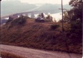
The Clark Brothers pulp mill was built on the east end of the bridge around World War I but quickly went out of business. It's ruined concrete structure remained beside the tracks until the 1980s.
Is this the Bear River Bridge?
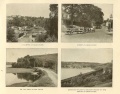
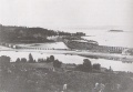
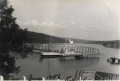
Bear River Bridge and adjacent scenes circa 1890s.
East end of bridge, circa 1890s
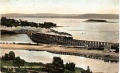
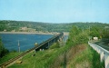
The Bear River railway bridge in the background, circa 1900, with the old highway bridge on left and the new highway bridge on right.
Photograph of the Flying Bluenose, Train No. 124 crossing the Bear River Bridge, circa 1906.
Colourized postcard of the Flying Bluenose, Train No. 124 crossing the Bear River Bridge, circa 1906.
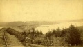
Colourized postcard from the Nova Scotia Museum of the eastern end of the Bear River railway bridge.
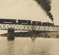
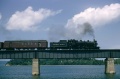
Train No. 98 led by No. 2617 on the Bear River Bridge on July 3, 1954.
Train No. 98 on July 3, 1954.
Train No. 98 on July 3, 1954.
Train No. 98 led by No. 2617 on the Bear River Bridge approaching Bear River station on July 3, 1954.
Train No. 98 led by No. 2617 on the Bear River Bridge approaching Bear River station on July 3, 1954.
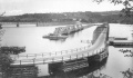
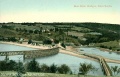
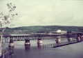
The second highway bridge in 1956 showing the swing span open for the passage of ships.

Dayliner No. 9059 crossing the Bear River Bridge eastward in August 1959.
Bridge in 1960s showing ruins of Clark Brothers pulp mill.
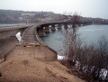
Swing bridge over the Bear River at Bear River, NS August 5, 1973 with ruins of Clark Brothers pulp mill.
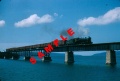
Taken from east end looking west -Hwy. 101 on the left.
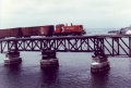
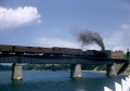
No. 1271 leads an Eastbound freight across the Bear River Bridge in 1989.
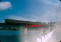
A hi-railer makes its way east across the Bear River Bridge.


.jpg)


References
- (1) DOMINION ATLANTIC RAILWAY. PLAN SHOWING REVISION OF LINE AT BEAR RIVER BRIDGE, May 1, 1912. Item (linked). 71/5705 CA. RG2M 71/5705, Library and Archives Canada.
- (2) Memorandum of General Information on the Dominion Atlantic Railway, Feb. 17, 1969, page 16, Dominion Atlantic Railway, Library and Archives Canada HE2810 D7 D7 fol.
- (3) List of Lights, Canadian Dept. of Transport, 1941, p. 39.