Dominion Atlantic Railway Digital Preservation Initiative - Wiki
Use of this site is subject to our Terms & Conditions.
Difference between revisions of "Bear River"
Dan conlin (talk | contribs) (image) |
Dan conlin (talk | contribs) (image) |
||
| Line 11: | Line 11: | ||
Image:1903-LANDOFEVANGELINE-P18.jpg|Bear River circa 1890s. | Image:1903-LANDOFEVANGELINE-P18.jpg|Bear River circa 1890s. | ||
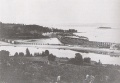
Image:1903-LANDOFEVANGELINE-P19.jpg|Bear River circa 1890s. | Image:1903-LANDOFEVANGELINE-P19.jpg|Bear River circa 1890s. | ||
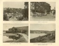
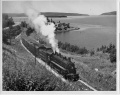
| − | Image:Digby.jpg|DAR train at the Bear River | + | Image:BearRiverBridged.jpg|Bear River station area to west of [[Bear River Bridge]] with [[Flying Bluenose]], [[Train No. 124]], circa 1906. |
| − | Image:R-105.jpg|[[DAR2528|No. 2528]] at the [[Bear River]] | + | Image:BearRiver.jpg|Bear River Station |
| + | Image:Digby.jpg|DAR train at the Bear River Curve, circa 1900. | ||
| + | Image:R-105.jpg|[[DAR2528|No. 2528]] at the [[Bear River]] Curve, circa 1950. | ||
Image:DAR main near Bear R NS 8-5-73.jpg|Bear River Curve 1973. | Image:DAR main near Bear R NS 8-5-73.jpg|Bear River Curve 1973. | ||
| − | |||
</Gallery> | </Gallery> | ||
Revision as of 19:18, 20 March 2009
Bear River, Nova Scotia
Subdivision Yarmouth, Mile 13.6
Bear River had a large wooden passenger and freight station built to Intercolonial Railway plans by the federal government when they constructed the missing link between Annapolis Royal and Digby including the massive Bear River Bridge, a mile east of the station.
914 foot Passing track at station.
Elevation: 42 feet
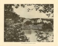
Bear River circa 1890s.
Bear River circa 1890s.
Bear River station area to west of Bear River Bridge with Flying Bluenose, Train No. 124, circa 1906.
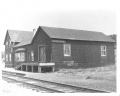
Bear River Station
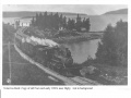
DAR train at the Bear River Curve, circa 1900.
No. 2528 at the Bear River Curve, circa 1950.
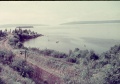
Bear River Curve 1973.


References
Memorandum of General Information on the Dominion Atlantic Railway, Feb. 17, 1969, Dominion Atlantic Railway, Library and Archives Canada HE2810 D7 D7 fol.