Dominion Atlantic Railway Digital Preservation Initiative - Wiki
Use of this site is subject to our Terms & Conditions.
Difference between revisions of "File:Windsor 1941 Sheet1.jpg"
Dan Conlin (talk | contribs) (Windsor Fire Insurance Map, Sheet 1, an overall view of Windsor providing a guide to areas covered by individual map sheets as well as the route of the DAR mainline through Windsor. Note the location of the Windsor Enginehouse. The original map was made in May 1934 and updated to July 1941. Note: Fire insurance plans provide detailed information on structures, but only approximate information on track layout. See the railway's [[:Category:Track_Chart...) |
Dan Conlin (talk | contribs) m |
||
| Line 4: | Line 4: | ||
Note: Fire insurance plans provide detailed information on structures, but only approximate information on track layout. See the railway's [[:Category:Track_Charts|Track Charts]] for precise information on track switches and siding. | Note: Fire insurance plans provide detailed information on structures, but only approximate information on track layout. See the railway's [[:Category:Track_Charts|Track Charts]] for precise information on track switches and siding. | ||
| − | Courtesy [[:Category:Irvin Leopold|Irvin Leopold]], photographed from Fire Insurance Album owned by Eric Stephens and shared in a [https://www.facebook.com/permalink.php?story_fbid=pfbid02N2MvSfMpsxpFwE2vnjsGm47CX2wXUNCtq2HemZuRKPauwterigRi5LkcmT7yvoNPl&id=100068760874436 May 17, 2024 Facebook Post] | + | Courtesy [[:Category:Irvin Leopold Photo|Irvin Leopold]], photographed from Fire Insurance Album owned by Eric Stephens and shared in a [https://www.facebook.com/permalink.php?story_fbid=pfbid02N2MvSfMpsxpFwE2vnjsGm47CX2wXUNCtq2HemZuRKPauwterigRi5LkcmT7yvoNPl&id=100068760874436 May 17, 2024 Facebook Post] |
[[Category:Irvin Leopold Photo]] | [[Category:Irvin Leopold Photo]] | ||
[[Category:Fire Insurance Maps]] | [[Category:Fire Insurance Maps]] | ||
Latest revision as of 07:23, 19 May 2024
Summary
Windsor Fire Insurance Map, Sheet 1, an overall view of Windsor providing a guide to areas covered by individual map sheets as well as the route of the DAR mainline through Windsor. Note the location of the Windsor Enginehouse. The original map was made in May 1934 and updated to July 1941.
Note: Fire insurance plans provide detailed information on structures, but only approximate information on track layout. See the railway's Track Charts for precise information on track switches and siding.
Courtesy Irvin Leopold, photographed from Fire Insurance Album owned by Eric Stephens and shared in a May 17, 2024 Facebook Post
File history
Click on a date/time to view the file as it appeared at that time.
| Date/Time | Thumbnail | Dimensions | User | Comment | |
|---|---|---|---|---|---|
| current | 07:22, 19 May 2024 | 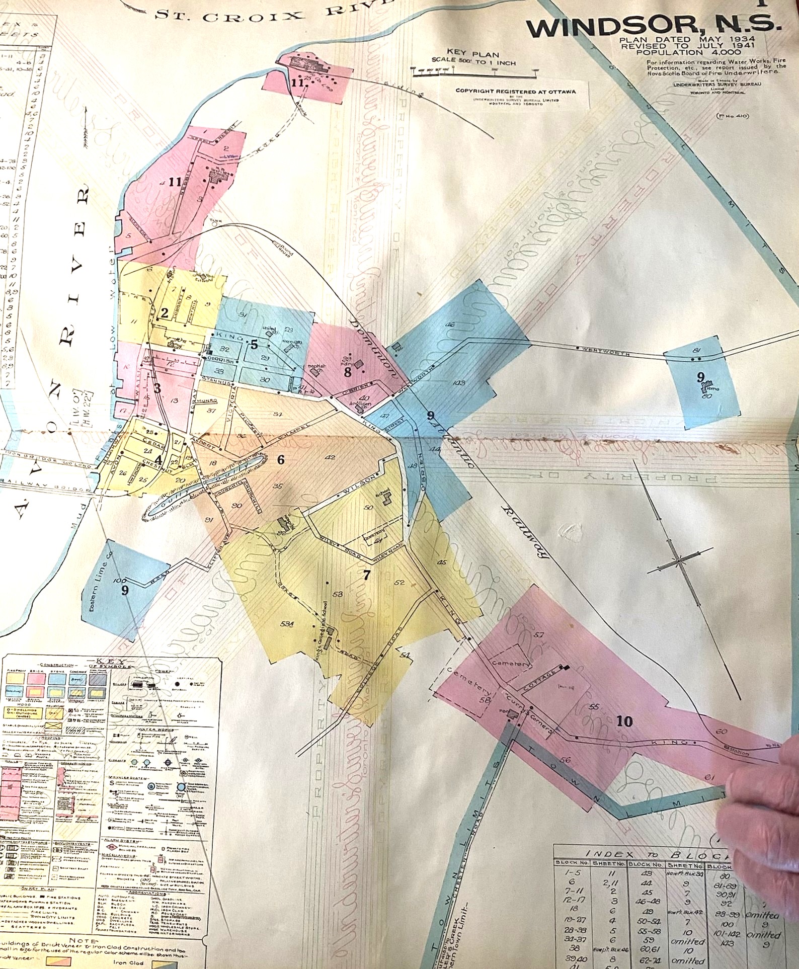 | 1,588 × 1,926 (863 KB) | Dan Conlin (talk | contribs) | Windsor Fire Insurance Map, Sheet 1, an overall view of Windsor providing a guide to areas covered by individual map sheets as well as the route of the DAR mainline through Windsor. Note the location of the Windsor Enginehouse. The original map was made in May 1934 and updated to July 1941. Note: Fire insurance plans provide detailed information on structures, but only approximate information on track layout. See the railway's [[:Category:Track_Chart... |
You cannot overwrite this file.
File usage
The following 2 pages use this file: