Dominion Atlantic Railway Digital Preservation Initiative - Wiki
Use of this site is subject to our Terms & Conditions.
Difference between revisions of "Groves"
Dan Conlin (talk | contribs) (Created page with "=Groves= Mile 8.56 from Windsor Junction on the Halifax Subdivision (Mile 24.6 from Halifax) *Next Station East: Fenerty's *Ne...") |
Dan Conlin (talk | contribs) (footnote) |
||
| (7 intermediate revisions by the same user not shown) | |||
| Line 1: | Line 1: | ||
| − | =Groves= | + | __NOTITLE__ __NOTOC__ |
| + | =Groves Siding= | ||
Mile 8.56 from [[Windsor Junction]] on the [[:Category:Subdivision Halifax|Halifax Subdivision]] (Mile 24.6 from [[Halifax]]) | Mile 8.56 from [[Windsor Junction]] on the [[:Category:Subdivision Halifax|Halifax Subdivision]] (Mile 24.6 from [[Halifax]]) | ||
| + | |||
| + | Elevation: 456 feet | ||
*Next Station East: [[Fenerty's]] | *Next Station East: [[Fenerty's]] | ||
| Line 10: | Line 13: | ||
==Description & History== | ==Description & History== | ||
| − | The siding | + | In the early years of the line, Groves served as the station for the small lumbering community of Bushy Hill nearby. In later years the settlement dwindled and Groves operated mainly as a siding. The location may have been named after a prominent grove of trees<ref>[https://archives.novascotia.ca/places/page/?ID=265 "Groves, Halifax County", ''Place-names and Places of Nova Scotia'', Nova Scotia Archives, p. 265]</ref> or the siding may have been named after the Groves family based at nearby [[Beaver Bank]] who operated a variety of enterprises in the area including box making, brick making, farming and saw milling.<ref>[https://www.fultzhouse.ca/brochures/Grove.pdf "the Story Behind the Grove Finishing School", ''Fultz House Museum'']</ref> |
==Commerce & Industry== | ==Commerce & Industry== | ||
| − | Groves was the location of a quarry. | + | Groves was also the location of a quarry. |
==Gallery== | ==Gallery== | ||
<Gallery perrow=5> | <Gallery perrow=5> | ||
| − | File:HA- | + | File:HA-08.63 Grove's.jpg|1918 Track Chart of Groves |
File:Uniacke_11_D13.jpg|Topographic map from Stillwater to Windsor Junction circa 1956. | File:Uniacke_11_D13.jpg|Topographic map from Stillwater to Windsor Junction circa 1956. | ||
</Gallery> | </Gallery> | ||
| + | |||
| + | ==References== | ||
| + | |||
| + | [[Category:Locations]] | ||
| + | [[Category:Subdivision Halifax|HA-08.56]] | ||
Latest revision as of 08:32, 26 May 2022
Groves Siding
Mile 8.56 from Windsor Junction on the Halifax Subdivision (Mile 24.6 from Halifax)
Elevation: 456 feet
- Next Station East: Fenerty's
- Next Station West: South Uniacke
Facilities & Features
- Siding. 1620 feet long. Capacity: 28 cars.
Description & History
In the early years of the line, Groves served as the station for the small lumbering community of Bushy Hill nearby. In later years the settlement dwindled and Groves operated mainly as a siding. The location may have been named after a prominent grove of trees[1] or the siding may have been named after the Groves family based at nearby Beaver Bank who operated a variety of enterprises in the area including box making, brick making, farming and saw milling.[2]
Commerce & Industry
Groves was also the location of a quarry.
Gallery
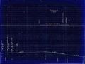
1918 Track Chart of Groves
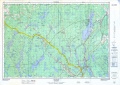
Topographic map from Stillwater to Windsor Junction circa 1956.

