Dominion Atlantic Railway Digital Preservation Initiative - Wiki
Use of this site is subject to our Terms & Conditions.
Difference between revisions of "Shaw's Bog"
From DARwiki
Dan conlin (talk | contribs) |
m |
||
| (4 intermediate revisions by one other user not shown) | |||
| Line 1: | Line 1: | ||
| − | __NOTITLE____NOTOC__=Shaw's Bog, Nova Scotia= | + | __NOTITLE____NOTOC__ |
| − | Mile 34. | + | ==Shaw's Bog, Nova Scotia== |
| + | Mile 34.54 from [[Windsor Junction]] on the [[:Category:Subdivision Halifax|Halifax Subdivision]] (Mile 50.41 from [[Halifax]]) | ||
Elevation: 150 feet | Elevation: 150 feet | ||
*Next Station East: [[Falmouth]] | *Next Station East: [[Falmouth]] | ||
| − | *Next Station West: [[ | + | *Next Station West: [[Mount Denson]] |
==Facilities & Features== | ==Facilities & Features== | ||
| Line 11: | Line 12: | ||
==Description & History== | ==Description & History== | ||
| − | This level stretch of track above a a boggy stretch of the Shey Brook was the summit | + | This level stretch of track above a a boggy stretch of the Shey Brook was the summit of a steep grade out of [[Falmouth]]. It was the location of an important passing siding, often used by [[:Category:Gypsum Trains|gypsum trains]] to break trains in two when snow or slippery rails made the climb out of Falmouth difficult. |
==Operations & Orders== | ==Operations & Orders== | ||
| Line 18: | Line 19: | ||
==Gallery== | ==Gallery== | ||
<Gallery perrow=5> | <Gallery perrow=5> | ||
| + | File:HA-34.54 Shaw's Bog.jpg|1918 Track Chart of Shaw's Bog | ||
File:Wolfville_21_H1_East.jpg|Topographic map from Avonport to Shaws Bog circa 1956. | File:Wolfville_21_H1_East.jpg|Topographic map from Avonport to Shaws Bog circa 1956. | ||
| + | File:DAR - RDC Passing through Mount Denson Falmouth Area-Harold Jenkins Photo-1970.jpg|A DAR [[:Category:RDC|RDC]] passing through the [[Falmouth]] looking west up the grade to [[Shaw's Bog]], photographed by [[:Category:Harold Jenkins Photo|Harold Jenkins]], 1970. | ||
</Gallery> | </Gallery> | ||
| Line 33: | Line 36: | ||
[[Category:Locations]] | [[Category:Locations]] | ||
| − | [[Category:Subdivision Halifax| | + | [[Category:Subdivision Halifax|HA-34.54]] |
Latest revision as of 12:06, 27 February 2020
Shaw's Bog, Nova Scotia
Mile 34.54 from Windsor Junction on the Halifax Subdivision (Mile 50.41 from Halifax)
Elevation: 150 feet
- Next Station East: Falmouth
- Next Station West: Mount Denson
Facilities & Features
- Passing Track 1,683 feet long[1]
Description & History
This level stretch of track above a a boggy stretch of the Shey Brook was the summit of a steep grade out of Falmouth. It was the location of an important passing siding, often used by gypsum trains to break trains in two when snow or slippery rails made the climb out of Falmouth difficult.
Operations & Orders
Gallery
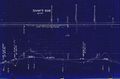
1918 Track Chart of Shaw's Bog

Topographic map from Avonport to Shaws Bog circa 1956.
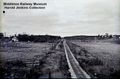
A DAR RDC passing through the Falmouth looking west up the grade to Shaw's Bog, photographed by Harold Jenkins, 1970.


