Dominion Atlantic Railway Digital Preservation Initiative - Wiki
Use of this site is subject to our Terms & Conditions.
Difference between revisions of "Digby"
Dan Conlin (talk | contribs) |
Dan Conlin (talk | contribs) (→Gallery: image) |
||
| Line 21: | Line 21: | ||
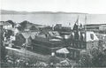
Image:1903-LANDOFEVANGELINE-P01.jpg|Digby circa 1890s. | Image:1903-LANDOFEVANGELINE-P01.jpg|Digby circa 1890s. | ||
Image:1903-LANDOFEVANGELINE-P02.jpg|Digby circa 1890s, with the Saint John-Digby ferry [[SS Prince Rupert]]. | Image:1903-LANDOFEVANGELINE-P02.jpg|Digby circa 1890s, with the Saint John-Digby ferry [[SS Prince Rupert]]. | ||
| + | File:202301046.jpg|Digby waterfront with DAR train at the [[Digby Wharf]] with the [[SS Prince Rupert]], circa 1900. | ||
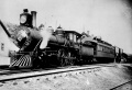
Image:Digby Fast Train.jpg|[[DAR0018|No. 18]] leading train at [[Digby]], circa 1894. | Image:Digby Fast Train.jpg|[[DAR0018|No. 18]] leading train at [[Digby]], circa 1894. | ||
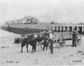
Image:JogginsHardy.jpg|[[Digby]] and [[The Joggins Bridge|the first Big Joggins Bridge]] as described in the brochure "The Evangeline Land", circa 1910. | Image:JogginsHardy.jpg|[[Digby]] and [[The Joggins Bridge|the first Big Joggins Bridge]] as described in the brochure "The Evangeline Land", circa 1910. | ||
Revision as of 11:45, 9 October 2025

Digby, Nova Scotia
Subdivision Yarmouth, Mile 20.2
Next Station East: Smith's Cove
Next Station West: Acaciaville
- Elevation 43'.
Features
Gallery

DAR 1918 track plan showing Digby, the west yard and the Digby Wye.
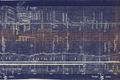
DAR 1918 track plan showing Digby and the east yard.
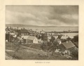
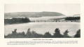
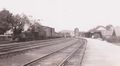
Digby circa 1890s.
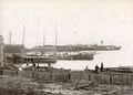
Digby circa 1890s, with the Saint John-Digby ferry SS Prince Rupert.
Digby waterfront with DAR train at the Digby Wharf with the SS Prince Rupert, circa 1900.
Digby and the first Big Joggins Bridge as described in the brochure "The Evangeline Land", circa 1910.
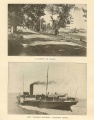
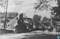
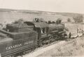
No. 11 at the Digby Station at Digby circa 1912.
A train possibly on the wharf spur at Digby.
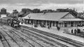
Postcard of Digby Station and Water Tower with eastbound DAR passenger train, 1921.
Digby Wharf from the beach. circa 1925.
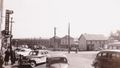
Nice shot of Digby with part of the yard and wharf in background, circa 1930.
Snowplow No. 907 with locomotive No. 537 at Digby Station, circa 1937.
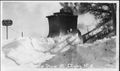
Snowplow at Digby, unknown date.
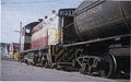
DAR No. 541 with freight at Digby Station with Digby Water Tower in background, October 1949.
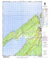
Topographical map of Digby, Acaciaville, Bloomfield and North Range, 1952
No. 1015 after collision with No. 1111 at Digby, with Big Joggins Bridge in the background July 19, 1956.
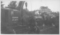
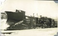
Crane No. 802 arrives to lift locomotive 1015 at Digby, July 19, 1956.
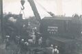
Wreck Crane No. 802 prepares to lift locomotive No. 1015 after collision with No. 1111 at Digby, July 19, 1956.
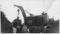
Crane No. 802 lifting locomotive 1015, after collision with No. 1111 at Digby, July 19, 1956.
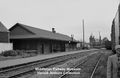
Digby Station, with unidentified fellow photographer in foreground and Digby Post office in background, photographed by Harold Jenkins, circa June 1959.
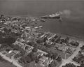
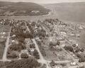
Aerial view of Digby from southwest showing the Digby waterfront. The station and railyard is visible at left of the photo, late 1950s.
Aerial view of Digby from south showing the Digby Station, Digby Railyard, the Digby Pines and the spur to the Digby Wharf, circa late 1950s.
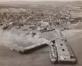
Aerial view of Digby from the east with Princess Helene at the Digby Wharf and the Digby Station in background, circa late 1950s.
View from a passenger train just after leaving the Digby Wharf in October, 1949.
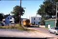
Engine 8133 going though Digby in June 1967, just near Mileage Marker 20.
Albert "Shine" Manning & Mel Alexander at Digby Station with meet of DAR Train No. 1 and Train No. 2, May 26, 1977.
Conductor Albert "Shine" Manning throws a switch at Digby with Digby Station in background,June 27, 1977.
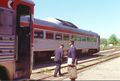
VIA RDC Travelling though Digby in August 1989

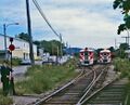
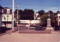
A short freight is eastbound through Digby in November 1989.

A short freight is eastbound through Digby along First Ave. in November 1989.
A short freight is eastbound through Digby along First Ave. in November 1989.

Mile 20 still exists in Digby. The beige building with three skylights sits on the roadbed close to the location of the old station. March 3, 2007

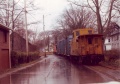
Looking railway west at Digby. The mainline ran along the side of the street. March 3, 2007.


_at_Digby_Oct_1949.jpg)


References and Footnotes
1969 Memorandum of General Information, Digby facilities and customers, p. 16
External Links
- Nova Scotia Archives, Good zoomable air view of Digby rail yard, station, spur to wharf, and Digby Pines, circa, 1960
- Wonderful colour 8 mm film of DAR steam locomotives and RDCs at Digby Station and wharves, 1950s, courtesy Admiral Digby Museum
- General view of Digby, showing where the wharf spur left the mainline adjacent to the post office. Train on wharf. - Canada Science and Technology Museum Image STR04096a.