Dominion Atlantic Railway Digital Preservation Initiative - Wiki
Use of this site is subject to our Terms & Conditions.
Difference between revisions of "North Range"
From DARwiki
Dan Conlin (talk | contribs) m |
Dan Conlin (talk | contribs) (map) |
||
| Line 10: | Line 10: | ||
==Gallery== | ==Gallery== | ||
<Gallery> | <Gallery> | ||
| + | File:Digby 21 A12 West.jpg|Topographical map of [[Digby]], [[Acaciaville]], [[Bloomfield]] and [[North Range]], 1952. | ||
File:NorthRangeFlatcar.jpg|[[North Range Station]], January 1951. | File:NorthRangeFlatcar.jpg|[[North Range Station]], January 1951. | ||
Image:North_Range_Crossing.jpg|[[North Range]] Crossing Road level crossing, January 1951. | Image:North_Range_Crossing.jpg|[[North Range]] Crossing Road level crossing, January 1951. | ||
Latest revision as of 10:29, 10 January 2025
North Range, Nova Scotia
Subdivision Yarmouth, Mile 30.4
Next Station East: Bloomfield
Next Station West: Plympton
Features and Facilities
Gallery
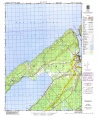
Topographical map of Digby, Acaciaville, Bloomfield and North Range, 1952.
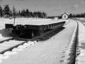
North Range Station, January 1951.
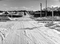
North Range Crossing Road level crossing, January 1951.
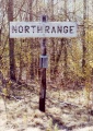
North Range sign post. 1991.
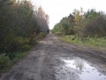
North Range looking railway west, Oct. 17, 2006.


