Dominion Atlantic Railway Digital Preservation Initiative - Wiki
Use of this site is subject to our Terms & Conditions.
Difference between revisions of "Bear River Bridge"
Dan Conlin (talk | contribs) |
|||
| (32 intermediate revisions by 4 users not shown) | |||
| Line 1: | Line 1: | ||
| + | __NOTITLE____NOTOC__ | ||
| + | =[[Bear River]] Bridge= | ||
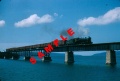
[[Image:PC-56-38 Bridge over Bear River (digby county).jpg|thumb|right|300px|The [[Bear River]] Bridge looking east in the 1960s.]] | [[Image:PC-56-38 Bridge over Bear River (digby county).jpg|thumb|right|300px|The [[Bear River]] Bridge looking east in the 1960s.]] | ||
Mile 12.86 on the [[:Category:Subdivision Yarmouth|Yarmouth Subdivision]]. Just east of the [[Bear River]] station. | Mile 12.86 on the [[:Category:Subdivision Yarmouth|Yarmouth Subdivision]]. Just east of the [[Bear River]] station. | ||
| − | At 1640 feet in length, this was the largest bridge on the DAR. It crossed the wide tidal mouth of the Bear River. This bridge, along with the [[Clementsport Bridge]] and [[The Joggins Bridge]], were the key challenges in the "missing link" between the [[Annapolis Royal]] and [[Digby]]. The bridge was completed by the federal government in 1890 allowing the [[Windsor and Annapolis Railway]] and the [[Western Counties Railway]] to connect and form the Dominion Atlantic Railway. There were two versions of the bridge, the first wooden bridge built in 1890 and its steel replacement built slightly to the north starting in 1912 and completed by 1913. Both contained a large swing span on the far west end of the bridge to allow sailing vessels passage to the busy timber wharves in the village of Bear River several miles upriver. | + | At 1640 feet in length, this was the largest bridge on the DAR, and the second longest bridge in Nova Scotia.<ref>The Intercolonial Railway's Grand Narrows Bridge in Cape Breton at 1,700 feet was slightly longer. [https://saltwire.pressreader.com/@Reader14543657/csb_uzPGCcBCtv5SjYYP5RR1HoR-NXrmh7r7UPbkhRCHr-sNFgIofp4akX5IcJDj8yDf Vanessa Childs Rolls, "Building the Grand Narrows Bridge was No Simple Feat", ''Cape Breton Post'', Saltwite Network, June 27, 2020]</ref> It crossed the wide tidal mouth of the Bear River. This bridge, along with the [[Clementsport Bridge]] and [[The Joggins Bridge]], were the key challenges in the "missing link" between the [[Annapolis Royal]] and [[Digby]]. The bridge was completed by the federal government in 1890 allowing the [[Windsor and Annapolis Railway]] and the [[Western Counties Railway]] to connect and form the Dominion Atlantic Railway. There were two versions of the bridge, the first wooden bridge built in 1890 and its steel replacement built slightly to the north starting in 1912 and completed by 1913.<ref>DOMINION ATLANTIC RAILWAY. PLAN SHOWING REVISION OF LINE AT BEAR RIVER BRIDGE, May 1, 1912. Item (linked). 71/5705 CA. RG2M 71/5705, Library and Archives Canada.</ref> and <ref>DOMINION ATLANTIC RAILWAY. BEAR RIVER BRIDGE. MASONRY PLANS OF PIERS, Oct 24, 1913. RG2 71/5705, e010775547 Library and Archives Canada.</ref> Both contained a large swing span on the far west end of the bridge to allow sailing vessels passage to the busy timber wharves in the village of Bear River several miles upriver.The bridge was abandoned in 1990 and demolished in 2012. The bridge was documented before the demolition in 2010 by the archaeological firm Davis MacIntyre & Associates.<ref>[https://www.davismacintyre.com/dig-annap-rail-bridges "Digby & Annapolis County Rail Bridges", Past Projects, Davis MacIntyre & Associates Archaeological Consultants]</ref> |
| − | Structure: 1640 feet long in its final configuration | + | ==Specifications== |
| + | Structure: 1640 feet long in its final configuration<ref>[[1969-MemoOfGenInfo|''Memorandum of General Information on the Dominion Atlantic Railway'', Feb. 17, 1969,]] page 16, Dominion Atlantic Railway, Library and Archives Canada HE2810 D7 D7 fol.</ref>, it included from east to west: | ||
| − | One | + | *One 39-foot Deck Plate Girder Span |
| + | *Six 100-foot Deck Plate Girder spans | ||
| + | *Three 156 feet 9¼ inches Deck Truss spans | ||
| + | *One 144 feet 6 inches Deck Truss Swing span | ||
| + | *One 156 feet 9¼ inches Deck Truss span | ||
| + | *One 103 feet 3 inches Deck Plate Girder span | ||
| + | *One 50 feet 1 inch Deck Plate Girder span. | ||
| + | (Span lengths taken from a 1918 profile drawing at [[:File:YA-13.62 Bear River.jpg|File:YA-13.62 Bear River.jpg]].) | ||
| − | A | + | A hidden feature on the swing bridge were the underwater wooden pilings driven on both sides of the approach to protect the swing span piers from collision damage. |
| − | The [[Clarke Brothers Pulp Mill]] was built on the east end of the bridge in 1919 but went out of business in 1923. | + | A 32 foot "pepperpot" wooden lighthouse was built beside the west end of the bridge in 1905.<ref>''List of Lights'', Canadian Dept. of Transport, 1941, p. 39.</ref> |
| + | |||
| + | The [[Clarke Brothers Pulp Mill]] was built on the east end of the bridge in 1919 but went out of business in 1923. The mill's brick and concrete structure was used for other purposes and remained beside the tracks until the late 1980s. | ||
==Wooden Pile and Truss Bridge 1890-1913== | ==Wooden Pile and Truss Bridge 1890-1913== | ||
| − | <gallery | + | <gallery> |
Image:1903-LANDOFEVANGELINE-P19.jpg|Bear River Bridge and adjacent scenes circa 1890s. | Image:1903-LANDOFEVANGELINE-P19.jpg|Bear River Bridge and adjacent scenes circa 1890s. | ||
Image:PH-56-8 Bear River Bridge.jpg|East end of bridge, circa 1890s | Image:PH-56-8 Bear River Bridge.jpg|East end of bridge, circa 1890s | ||
| Line 19: | Line 31: | ||
Image:BearRiverBridged.jpg|Photograph of the [[Flying Bluenose]], [[Train No. 124]] crossing the [[Bear River Bridge]], circa 1906. | Image:BearRiverBridged.jpg|Photograph of the [[Flying Bluenose]], [[Train No. 124]] crossing the [[Bear River Bridge]], circa 1906. | ||
Image:BearRiverBridgeb.jpg|Colourized postcard of the [[Flying Bluenose]], [[Train No. 124]] crossing the [[Bear River Bridge]], circa 1906. | Image:BearRiverBridgeb.jpg|Colourized postcard of the [[Flying Bluenose]], [[Train No. 124]] crossing the [[Bear River Bridge]], circa 1906. | ||
| + | File:Bear River First Bridge.jpg|[[Bear River Bridge]] showing movable span opened. Date unknown. | ||
| + | File:CSTM-STR04099a 001 aa cs.jpg |[[Bear River Bridge]], looking east, 1906 | ||
Image:BearRiverBridgea.jpg|Colourized postcard from the [[:Category:Nova Scotia Museum|Nova Scotia Museum]] of the eastern end of the Bear River railway bridge. | Image:BearRiverBridgea.jpg|Colourized postcard from the [[:Category:Nova Scotia Museum|Nova Scotia Museum]] of the eastern end of the Bear River railway bridge. | ||
</gallery> | </gallery> | ||
| − | |||
| − | |||
| − | |||
| − | ==Steel Plate Girder and Truss Bridge 1913- | + | ==Steel Plate Girder and Truss Bridge 1913-2012== |
| − | <gallery | + | <gallery> |
| − | File:DAR and Victoria Bridges at Bear River, NS No Date.jpg | + | YA-12.86 Bear River Bridge.jpeg|Bear River Bridge Track Profile |
| + | File:Bear River Bridge Construction 1.jpg|Bear River bridge under construction. | ||
| + | File:Bear River Bridge Construction 2.jpg|Bear River bridge under construction. | ||
| + | File:Bear River Bridge Construction 3.jpg|Bear River bridge under construction. | ||
| + | File:Bear River Bridge Construction 4.jpg|Bear River bridge under construction. | ||
| + | File:Bear River Bridge Construction 5.jpg|Bear River bridge under construction. | ||
| + | File:DAR and Victoria Bridges at Bear River, NS No Date.jpg|Early view of new steel Bear River railway bridge and Victoria highway bridge, viewed from southwest. | ||
Image:Bearrivermill.jpg|Artist's rendering of [[Clarke Brothers Pulp Mill]] beside the [[Bear River Bridge]], circa 1919. | Image:Bearrivermill.jpg|Artist's rendering of [[Clarke Brothers Pulp Mill]] beside the [[Bear River Bridge]], circa 1919. | ||
| − | File:McBrideAlbum1 July 18 1937.jpg|"President's Special" crossing the [[Bear River Bridge]] with [[DAR0537|locomotive No. 537]] | + | File:Kalkman114.jpg|A photographic postcard showing the eastbound [[Flying Bluenose]] passenger train crossing the [[Bear River Bridge]], circa 1920. |
| − | File:NSIS4680.jpg|[[Train No. 95]] pulled by [[DAR2552|Locomotive No. 2552]] crossing the [[Bear River Bridge]] with the ruins of the [[Clarke Brothers Pulp Mill]] to | + | File:Kalkman23.jpg|[[Bear River Bridge]] with the [[Clarke Brothers Pulp Mill]] in background, Aug. 31, 1920. |
| + | File:Bear River Pulp Mill.jpg|A postcard of the [[Clarke Brothers Pulp Mill]] at [[Bear River]] soon after it opened, circa 1921. | ||
| + | File:McBrideAlbum1 July 18 1937.jpg|"President's Special" crossing the [[Bear River Bridge]] with [[DAR0537|locomotive No. 537]] and business cars "St. Andrew"; "Wentworth" and "Thorold", July 18, 1937. | ||
| + | File:McBride2p51C.jpg|Eastbound mixed train on the [[Bear River Bridge]] with [[:Category:Refrigerator Cars|refrigerator cars]], circa winter 1937. | ||
| + | File:NSIS4680.jpg|[[Train No. 95]] pulled by [[DAR2552|Locomotive No. 2552]] crossing the [[Bear River Bridge]] with the ruins of the [[Clarke Brothers Pulp Mill]] to left, circa 1950. | ||
| + | File:201307157.jpg|The [[Bear River Bridge]] with ruins of the [[Clarke Brothers Pulp Mill]] in the background, Dec. 1950. | ||
Image:Train No. 98 on Bear River Bridge 3.jpg|[[Train No. 98]] led by [[DAR2617|No. 2617]] on the [[Bear River Bridge]] on July 3, 1954. | Image:Train No. 98 on Bear River Bridge 3.jpg|[[Train No. 98]] led by [[DAR2617|No. 2617]] on the [[Bear River Bridge]] on July 3, 1954. | ||
Image:Train No. 98 on Bear River Bridge.jpg|Train No. 98 on July 3, 1954. | Image:Train No. 98 on Bear River Bridge.jpg|Train No. 98 on July 3, 1954. | ||
| Line 38: | Line 60: | ||
Image:BearRiverBridgef.jpg|The second highway bridge in 1956 showing the swing span open for the passage of ships. | Image:BearRiverBridgef.jpg|The second highway bridge in 1956 showing the swing span open for the passage of ships. | ||
Image:Bear River Bridge with RDC.jpg|Dayliner [[DAR9059|No. 9059]] crossing the [[Bear River Bridge]] eastward in August 1959. | Image:Bear River Bridge with RDC.jpg|Dayliner [[DAR9059|No. 9059]] crossing the [[Bear River Bridge]] eastward in August 1959. | ||
| + | File:DAR - Bear River Bridge A-Harold Jenkins Photo-Summertime1960.JPG|[[Bear River Bridge]], looking west, Summer 1960. | ||
| + | File:DAR - Bear River Bridge C-Harold Jenkins Photo-Summertime 1960.JPG|[[Bear River Bridge]] with highway bridge to the left and lighthouse to right, Summer 1960. | ||
| + | File:DAR - Bear River Bridge B-Harold Jenkins Photo-Unknown Date-Summertime1960.JPG|[[Bear River Bridge]], looking west with the former [[Clarke Brothers Pulp Mill]] in foreground, Summer 1960. | ||
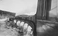
Image:PC-56-38 Bridge over Bear River (digby county).jpg|Bridge in 1960s showing ruins of [[Clarke Brothers Pulp Mill]]. | Image:PC-56-38 Bridge over Bear River (digby county).jpg|Bridge in 1960s showing ruins of [[Clarke Brothers Pulp Mill]]. | ||
| − | File:CSTM-STR09772a 001 aa cs.jpg | Bear River Bridge with an RDC on it, Summer 1969 | + | File:Bear River Bridge Centre Span Circa 1968.jpeg|Swing Bridge section at low tide cerca 1968. |
| + | File:CSTM-STR09772a 001 aa cs.jpg | Bear River Bridge with an RDC on it, Summer 1969. | ||
Image:Bear River bridge, Bear River, NS 8-5-73 060.jpg|Swing bridge over the Bear River at Bear River, NS August 5, 1973 with ruins of [[Clarke Brothers Pulp Mill]]. | Image:Bear River bridge, Bear River, NS 8-5-73 060.jpg|Swing bridge over the Bear River at Bear River, NS August 5, 1973 with ruins of [[Clarke Brothers Pulp Mill]]. | ||
| + | File:36-005a Bear River Bridge 790613.jpg|[[Bear River Bridge]] from the cab of an RDC on June 13, 1979. | ||
Image:1272bearriver1.jpg|[[CPR1272|No. 1272]] gently eases across the [[Bear River Bridge]] in the winter of 1988. | Image:1272bearriver1.jpg|[[CPR1272|No. 1272]] gently eases across the [[Bear River Bridge]] in the winter of 1988. | ||
Image:1272bearriver2.jpg|[[CPR1272|No. 1272]] makes its way East across the [[Bear River Bridge]] in the winter of 1988. | Image:1272bearriver2.jpg|[[CPR1272|No. 1272]] makes its way East across the [[Bear River Bridge]] in the winter of 1988. | ||
| Line 56: | Line 83: | ||
File:BearRiver 9.jpg|[[Bear River Bridge]] on March 22, 2012. | File:BearRiver 9.jpg|[[Bear River Bridge]] on March 22, 2012. | ||
File:BearRiver 10.jpg|[[Bear River Bridge]] facing east on March 22, 2012. | File:BearRiver 10.jpg|[[Bear River Bridge]] facing east on March 22, 2012. | ||
| − | |||
</gallery> | </gallery> | ||
[[Category:Bridges]] | [[Category:Bridges]] | ||
==References== | ==References== | ||
| − | + | <references/> | |
| − | + | ||
| − | |||
| − | |||
| − | |||
==External Links== | ==External Links== | ||
*[http://www.novanewsnow.com/article-168898-35-YEARS-AGO-New-bridge-opens-across-Bear-River.html 35 YEARS AGO: New bridge opens across Bear River] | *[http://www.novanewsnow.com/article-168898-35-YEARS-AGO-New-bridge-opens-across-Bear-River.html 35 YEARS AGO: New bridge opens across Bear River] | ||
*[http://www.gov.ns.ca/nsarm/virtual/nsis/archives.asp?ID=329&Language=English Nova Scotia Archives, No. 2552 on the Bear River Bridge.] | *[http://www.gov.ns.ca/nsarm/virtual/nsis/archives.asp?ID=329&Language=English Nova Scotia Archives, No. 2552 on the Bear River Bridge.] | ||
| + | *[http://ns1758.ca/rail/dar-bridge-bearriv.html "Dominion Atlantic Railway Bear River Bridge 1912 - 2012", ''Nova Scotia's Electronic Gleaner'': image and details of the demolition of the bridge in 2011 and 2012.] | ||
Latest revision as of 06:52, 25 August 2024
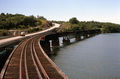
Bear River Bridge
.jpg)
Mile 12.86 on the Yarmouth Subdivision. Just east of the Bear River station.
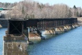
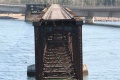
At 1640 feet in length, this was the largest bridge on the DAR, and the second longest bridge in Nova Scotia.[1] It crossed the wide tidal mouth of the Bear River. This bridge, along with the Clementsport Bridge and The Joggins Bridge, were the key challenges in the "missing link" between the Annapolis Royal and Digby. The bridge was completed by the federal government in 1890 allowing the Windsor and Annapolis Railway and the Western Counties Railway to connect and form the Dominion Atlantic Railway. There were two versions of the bridge, the first wooden bridge built in 1890 and its steel replacement built slightly to the north starting in 1912 and completed by 1913.[2] and [3] Both contained a large swing span on the far west end of the bridge to allow sailing vessels passage to the busy timber wharves in the village of Bear River several miles upriver.The bridge was abandoned in 1990 and demolished in 2012. The bridge was documented before the demolition in 2010 by the archaeological firm Davis MacIntyre & Associates.[4]
Specifications
Structure: 1640 feet long in its final configuration[5], it included from east to west:
- One 39-foot Deck Plate Girder Span
- Six 100-foot Deck Plate Girder spans
- Three 156 feet 9¼ inches Deck Truss spans
- One 144 feet 6 inches Deck Truss Swing span
- One 156 feet 9¼ inches Deck Truss span
- One 103 feet 3 inches Deck Plate Girder span
- One 50 feet 1 inch Deck Plate Girder span.
(Span lengths taken from a 1918 profile drawing at File:YA-13.62 Bear River.jpg.)
A hidden feature on the swing bridge were the underwater wooden pilings driven on both sides of the approach to protect the swing span piers from collision damage.
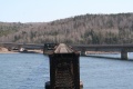
A 32 foot "pepperpot" wooden lighthouse was built beside the west end of the bridge in 1905.[6]
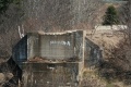
The Clarke Brothers Pulp Mill was built on the east end of the bridge in 1919 but went out of business in 1923. The mill's brick and concrete structure was used for other purposes and remained beside the tracks until the late 1980s.
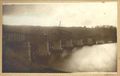
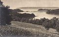
Wooden Pile and Truss Bridge 1890-1913
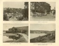
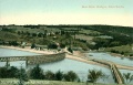
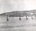
Bear River Bridge and adjacent scenes circa 1890s.
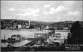
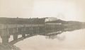
East end of bridge, circa 1890s
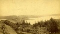
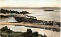
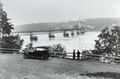
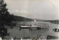
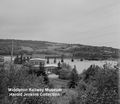
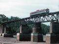
The Bear River railway bridge in the background, circa 1900, with the old highway bridge on left and the new highway bridge on right.
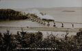
Photograph of the Flying Bluenose, Train No. 124 crossing the Bear River Bridge, circa 1906.
Colourized postcard of the Flying Bluenose, Train No. 124 crossing the Bear River Bridge, circa 1906.
Bear River Bridge showing movable span opened. Date unknown.
Bear River Bridge, looking east, 1906
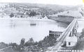
Colourized postcard from the Nova Scotia Museum of the eastern end of the Bear River railway bridge.


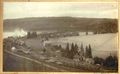
Steel Plate Girder and Truss Bridge 1913-2012
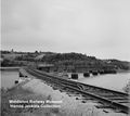
Bear River Bridge Track Profile
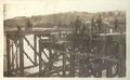
Bear River bridge under construction.
Bear River bridge under construction.
Bear River bridge under construction.
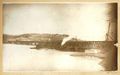
Bear River bridge under construction.
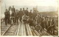
Bear River bridge under construction.
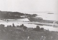
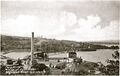
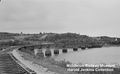
Early view of new steel Bear River railway bridge and Victoria highway bridge, viewed from southwest.
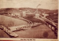
Artist's rendering of Clarke Brothers Pulp Mill beside the Bear River Bridge, circa 1919.
A photographic postcard showing the eastbound Flying Bluenose passenger train crossing the Bear River Bridge, circa 1920.
Bear River Bridge with the Clarke Brothers Pulp Mill in background, Aug. 31, 1920.
A postcard of the Clarke Brothers Pulp Mill at Bear River soon after it opened, circa 1921.
"President's Special" crossing the Bear River Bridge with locomotive No. 537 and business cars "St. Andrew"; "Wentworth" and "Thorold", July 18, 1937.
Eastbound mixed train on the Bear River Bridge with refrigerator cars, circa winter 1937.
Train No. 95 pulled by Locomotive No. 2552 crossing the Bear River Bridge with the ruins of the Clarke Brothers Pulp Mill to left, circa 1950.
The Bear River Bridge with ruins of the Clarke Brothers Pulp Mill in the background, Dec. 1950.
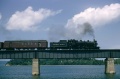
Train No. 98 led by No. 2617 on the Bear River Bridge on July 3, 1954.
Train No. 98 on July 3, 1954.
Train No. 98 on July 3, 1954.
Train No. 98 led by No. 2617 on the Bear River Bridge approaching Bear River station on July 3, 1954.
Train No. 98 led by No. 2617 on the Bear River Bridge approaching Bear River station on July 3, 1954.
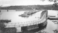
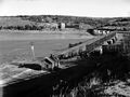
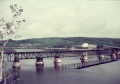
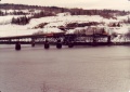
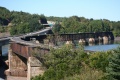
The second highway bridge in 1956 showing the swing span open for the passage of ships.

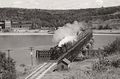
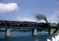
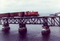
Dayliner No. 9059 crossing the Bear River Bridge eastward in August 1959.
Bear River Bridge, looking west, Summer 1960.
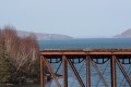
Bear River Bridge with highway bridge to the left and lighthouse to right, Summer 1960.
Bear River Bridge, looking west with the former Clarke Brothers Pulp Mill in foreground, Summer 1960.
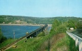
Bridge in 1960s showing ruins of Clarke Brothers Pulp Mill.
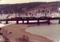
Swing Bridge section at low tide cerca 1968.
Bear River Bridge with an RDC on it, Summer 1969.
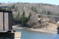
Swing bridge over the Bear River at Bear River, NS August 5, 1973 with ruins of Clarke Brothers Pulp Mill.
Bear River Bridge from the cab of an RDC on June 13, 1979.
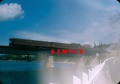
No. 1272 gently eases across the Bear River Bridge in the winter of 1988.
No. 1272 makes its way East across the Bear River Bridge in the winter of 1988.
No. 1271 leads an Eastbound freight across the Bear River Bridge in 1989.
A hi-railer makes its way east across the Bear River Bridge in the late 1980s.
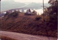
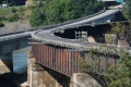
The abandoned bridge in 2008 after line closure, taken from east end looking west -Hwy. 101 on the left.
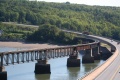
Bear River Bridge, facing east on September 1, 2011.
Bear River Bridge, facing west on September 1, 2011.
Bear River Bridge, facing west on September 1, 2011.
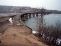
Bear River Bridge west end of bridge on March 22, 2012.
Bear River Bridge on March 22, 2012.
Bear River Bridge on March 22, 2012.
Bear River Bridge on March 22, 2012.

Bear River Bridge on March 22, 2012.
Bear River Bridge on March 22, 2012.
Bear River Bridge facing east on March 22, 2012.


.jpg)
.jpg)
.jpg)


References
- ↑ The Intercolonial Railway's Grand Narrows Bridge in Cape Breton at 1,700 feet was slightly longer. Vanessa Childs Rolls, "Building the Grand Narrows Bridge was No Simple Feat", Cape Breton Post, Saltwite Network, June 27, 2020
- ↑ DOMINION ATLANTIC RAILWAY. PLAN SHOWING REVISION OF LINE AT BEAR RIVER BRIDGE, May 1, 1912. Item (linked). 71/5705 CA. RG2M 71/5705, Library and Archives Canada.
- ↑ DOMINION ATLANTIC RAILWAY. BEAR RIVER BRIDGE. MASONRY PLANS OF PIERS, Oct 24, 1913. RG2 71/5705, e010775547 Library and Archives Canada.
- ↑ "Digby & Annapolis County Rail Bridges", Past Projects, Davis MacIntyre & Associates Archaeological Consultants
- ↑ Memorandum of General Information on the Dominion Atlantic Railway, Feb. 17, 1969, page 16, Dominion Atlantic Railway, Library and Archives Canada HE2810 D7 D7 fol.
- ↑ List of Lights, Canadian Dept. of Transport, 1941, p. 39.