Dominion Atlantic Railway Digital Preservation Initiative - Wiki
Use of this site is subject to our Terms & Conditions.
Difference between revisions of "Clementsport Bridge"
Dan Conlin (talk | contribs) m |
|||
| (30 intermediate revisions by 4 users not shown) | |||
| Line 3: | Line 3: | ||
Mile 7.67 on the Yarmouth Subdivision, spanning the Moose River. | Mile 7.67 on the Yarmouth Subdivision, spanning the Moose River. | ||
| − | + | This bridge, crossing the Moose River at [[Clementsport]], was the third largest on the Dominion Atlantic. It was built in 1890 at the same time as the [[Bear River Bridge]] and [[The Joggins Bridge]], to close the "missing link" between [[Annapolis Royal]] and [[Digby]]. The bridge was completed by the Federal Government allowing the [[Windsor and Annapolis Railway]] and the [[Western Counties Railway]] to combine and form the Dominion Atlantic Railway. There were two versions of the bridge. The first was a wooden Howe deck truss bridge built in 1890. The second was a steel deck truss bridge built in 1912 and completed by 1913. Both contained a large swing span in the centre to allow sailing vessels passage. The Clementsport Bridge was abandoned in 1990 and demolished in 2012, along with the [[Bear River Bridge]] and the [[Sissiboo River Bridge]] in [[Weymouth]]. The bridge was documented before the demolition by the archaeological firm Davis MacIntyre & Associates.<ref>[https://www.davismacintyre.com/dig-annap-rail-bridges "Digby & Annapolis County Rail Bridges", Past Projects, Davis MacIntyre & Associates Archaeological Consultants]</ref> | |
| + | Specs in the bridge's final form: Length: 894 feet long: open deck plate girder span, four deck truss spans, three deck plate girder spans on concrete piers. | ||
| + | |||
| + | ==First Bridge 1890-1912== | ||
<gallery> | <gallery> | ||
| + | File:Kalkman31.jpg|The [[Clementsport Bridge]] crossing Moose River looking east, early 1890s. | ||
| + | File:Gray3.jpg|The [[Clementsport Bridge]] in the closed position viewed from the northwesst, circa 1895. | ||
| + | File:Clementsport Bridge Closed.jpg|The [[Clementsport Bridge]] in the closed position viewed from the southwest, circa 1895. | ||
| + | File:Gray1.jpg|Postcard showing the first [[Clementsport Bridge]] open to allow an inbound schooner to enter the river, circa 1900. | ||
| + | File:Kalkman108.jpg|Postcard showing an eastbound passenger train crossing the [[Clementsport Bridge]], circa 1905. | ||
Image:ClementsportBridgea.jpg|[[:Category: Nova Scotia Museum|Nova Scotia Museum]] postcard of the [[Clementsport Bridge]] open for schooner, circa 1907. | Image:ClementsportBridgea.jpg|[[:Category: Nova Scotia Museum|Nova Scotia Museum]] postcard of the [[Clementsport Bridge]] open for schooner, circa 1907. | ||
| + | Image:BearRiverBridgee.jpg|Believed to be the [[Clementsport Bridge]] | ||
| + | File:201580067.jpg|The [[Clementsport Bridge]] open for an inbound schooner, circa 1895. | ||
| + | File:Clementsport Bridge.jpg|Postcard of first [[Clementsport Bridge]]. | ||
| + | File:Clementsport Bridge Back.jpg|Back of [[Clementsport Bridge]] postcard, postmarked 1912. | ||
Image:ClementsportBridgeb.jpg|[[Clementsport Bridge]] and wharves. | Image:ClementsportBridgeb.jpg|[[Clementsport Bridge]] and wharves. | ||
| − | + | File:YA-07.40 Clementsport.jpg|CPR Track chart showing track profile of [[Clementsport]] and the [[Clementsport Bridge]], Mar. 18, 1918. | |
| + | </gallery> | ||
| + | |||
| + | ==Second Bridge 1912-2012== | ||
| + | <gallery> | ||
| + | File:Gray2.jpg|The second [[Clementsport Bridge]] open for a two-masted schooner, circa 1915. | ||
| + | File:ClementsportBridge.jpg|A view of the [[Clementsport Bridge]] from on board a train. Circa 1920s. | ||
| + | File:Clementsport 2.jpg|[[Clementsport Bridge]], March 22, 2012. | ||
| + | File:McBride2p51D.jpg|Eastbound mixed train on the [[Clementsport Bridge]] with [[:Category:Refrigerator Cars|refrigerator cars]] from Digby and Yarmouth fish plants, circa winter 1937. | ||
| + | File:ClementsportBridge1941A1.jpg|[[Clementsport Bridge]] postcard mailed September 1941. | ||
| + | File:13321.jpg|[[Clementsport]] and the [[Clementsport Bridge]], air photo by the Nova Scotia Information Service, 1950s. | ||
| + | File:VIA Poster.jpg|VIA Rail poster for The [[Evangeline]] "Dayliner" with a westbound [[:Category:RDC|RDC]] on the [[Clementsport Bridge]], circa 1985. | ||
| + | File:Clementsport (Moose River) Bridge.jpg|Cab view of [[Clementsport Bridge]] - date unknown. | ||
Image:IMG 2715.JPG|[[Clementsport Bridge]] in July 2010 | Image:IMG 2715.JPG|[[Clementsport Bridge]] in July 2010 | ||
Image:IMG 2716.JPG|[[Clementsport Bridge]] in July 2010 | Image:IMG 2716.JPG|[[Clementsport Bridge]] in July 2010 | ||
File:Clementsport 1.jpg|[[Clementsport Bridge]], March 22, 2012. | File:Clementsport 1.jpg|[[Clementsport Bridge]], March 22, 2012. | ||
| − | + | File:Clementsport 3.jpg|[[Clementsport Bridge]] approach, March 22, 2012. | |
| − | File:Clementsport 3.jpg|[[Clementsport Bridge]], March 22, 2012. | ||
File:Clementsport 4.jpg|[[Clementsport Bridge]], March 22, 2012. | File:Clementsport 4.jpg|[[Clementsport Bridge]], March 22, 2012. | ||
</gallery> | </gallery> | ||
Latest revision as of 21:45, 2 August 2024
Clementsport Bridge
Mile 7.67 on the Yarmouth Subdivision, spanning the Moose River.
This bridge, crossing the Moose River at Clementsport, was the third largest on the Dominion Atlantic. It was built in 1890 at the same time as the Bear River Bridge and The Joggins Bridge, to close the "missing link" between Annapolis Royal and Digby. The bridge was completed by the Federal Government allowing the Windsor and Annapolis Railway and the Western Counties Railway to combine and form the Dominion Atlantic Railway. There were two versions of the bridge. The first was a wooden Howe deck truss bridge built in 1890. The second was a steel deck truss bridge built in 1912 and completed by 1913. Both contained a large swing span in the centre to allow sailing vessels passage. The Clementsport Bridge was abandoned in 1990 and demolished in 2012, along with the Bear River Bridge and the Sissiboo River Bridge in Weymouth. The bridge was documented before the demolition by the archaeological firm Davis MacIntyre & Associates.[1]
Specs in the bridge's final form: Length: 894 feet long: open deck plate girder span, four deck truss spans, three deck plate girder spans on concrete piers.
First Bridge 1890-1912
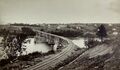
The Clementsport Bridge crossing Moose River looking east, early 1890s.
The Clementsport Bridge in the closed position viewed from the northwesst, circa 1895.
The Clementsport Bridge in the closed position viewed from the southwest, circa 1895.
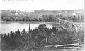
Postcard showing the first Clementsport Bridge open to allow an inbound schooner to enter the river, circa 1900.
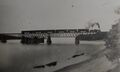
Postcard showing an eastbound passenger train crossing the Clementsport Bridge, circa 1905.
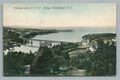
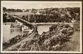
Nova Scotia Museum postcard of the Clementsport Bridge open for schooner, circa 1907.
Believed to be the Clementsport Bridge
The Clementsport Bridge open for an inbound schooner, circa 1895.
Postcard of first Clementsport Bridge.
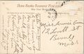
Back of Clementsport Bridge postcard, postmarked 1912.
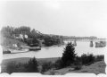
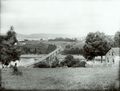
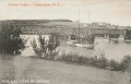
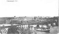
Clementsport Bridge and wharves.
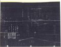
CPR Track chart showing track profile of Clementsport and the Clementsport Bridge, Mar. 18, 1918.


Second Bridge 1912-2012
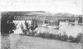
The second Clementsport Bridge open for a two-masted schooner, circa 1915.
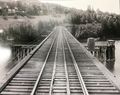
A view of the Clementsport Bridge from on board a train. Circa 1920s.

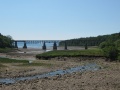
Clementsport Bridge, March 22, 2012.
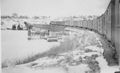
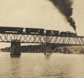
Eastbound mixed train on the Clementsport Bridge with refrigerator cars from Digby and Yarmouth fish plants, circa winter 1937.
Clementsport Bridge postcard mailed September 1941.
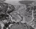
Clementsport and the Clementsport Bridge, air photo by the Nova Scotia Information Service, 1950s.

VIA Rail poster for The Evangeline "Dayliner" with a westbound RDC on the Clementsport Bridge, circa 1985.
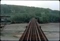
Cab view of Clementsport Bridge - date unknown.
Clementsport Bridge in July 2010
Clementsport Bridge in July 2010

Clementsport Bridge, March 22, 2012.

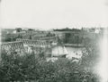
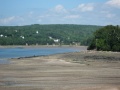
Clementsport Bridge approach, March 22, 2012.

Clementsport Bridge, March 22, 2012.


_Bridge.jpg)


References
Memorandum of General Information on the Dominion Atlantic Railway, Feb. 17, 1969, page 15, Dominion Atlantic Railway, Library and Archives Canada HE2810 D7 D7 fol.