Dominion Atlantic Railway Digital Preservation Initiative - Wiki
Use of this site is subject to our Terms & Conditions.
Difference between revisions of "Smith's Cove"
From DARwiki
Dan Conlin (talk | contribs) (Created page with "=Smith's Cove, Nova Scotia= Subdivision Yarmouth, Mile 15.56<br> Next Station East: Ibertville<br> Next Station West: Digby Active as a flag stop station from approxi...") |
Dan Conlin (talk | contribs) m |
||
| Line 4: | Line 4: | ||
Next Station West: [[Digby]] | Next Station West: [[Digby]] | ||
| − | Active as a flag stop station from approximately 1891 to 1951. | + | Active as a flag stop station from approximately 1891 to 1951, this station name however caused some local confusion as the community of Smith's Cove was located further east, and what the DAR called Smith's Cove was oftne called Joggin Bridge. In 1914, the DAR built a station in Smith's Cove but used the name [[Imbertville]] as a SMith's Cove Station already existed.<ref>[[The Homestead - 1981-07-16 - Annapolis Valley Saga|''The Homestead'' - 1981-July-16 - Review of ''Annapolis Valley Saga'']]</ref> |
<Gallery> | <Gallery> | ||
Revision as of 21:50, 7 April 2023
Smith's Cove, Nova Scotia
Subdivision Yarmouth, Mile 15.56
Next Station East: Ibertville
Next Station West: Digby
Active as a flag stop station from approximately 1891 to 1951, this station name however caused some local confusion as the community of Smith's Cove was located further east, and what the DAR called Smith's Cove was oftne called Joggin Bridge. In 1914, the DAR built a station in Smith's Cove but used the name Imbertville as a SMith's Cove Station already existed.[1]
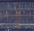
Track Schematic for Smith's Cove.
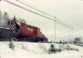
No 1828 at Smith's Cove.
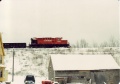
No 1828 at Smith's Cove.


