Dominion Atlantic Railway Digital Preservation Initiative - Wiki
Use of this site is subject to our Terms & Conditions.
Difference between revisions of "Category:Bird's Eye Maps"
From DARwiki
Dan Conlin (talk | contribs) (Created page with "Bird's eye maps were a series of artistically-interpreted aerial map views of Canadian towns and cities published in the 19th century. Other bird's eye views of DAR communitie...") |
Dan Conlin (talk | contribs) m |
||
| Line 1: | Line 1: | ||
| − | Bird's eye maps were a series of artistically-interpreted aerial map views of Canadian towns and cities published in the 19th century. Other bird's eye views of DAR communities included the [[Bird's Eve View of Kentville Nova Scotia 1879]], the [[Bird's Eve View of Windsor Nova Scotia 1878]] as well as bird's eyes of Truro | + | Bird's eye maps were a series of artistically-interpreted aerial map views of Canadian towns and cities published in the 19th century. Other bird's eye views of DAR communities included the [[Bird's Eve View of Kentville Nova Scotia 1879]], the [[Bird's Eve View of Windsor Nova Scotia 1878]], the [[Bird's Eve View of Yarmouth Nova Scotia 1889]] as well as bird's eyes of Truro and Halifax. |
==External Links== | ==External Links== | ||
Revision as of 19:58, 8 April 2022
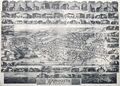
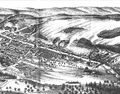
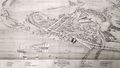
Bird's eye maps were a series of artistically-interpreted aerial map views of Canadian towns and cities published in the 19th century. Other bird's eye views of DAR communities included the Bird's Eve View of Kentville Nova Scotia 1879, the Bird's Eve View of Windsor Nova Scotia 1878, the Bird's Eve View of Yarmouth Nova Scotia 1889 as well as bird's eyes of Truro and Halifax.
External Links
Pages in category "Bird's Eye Maps"
The following 4 pages are in this category, out of 4 total.
Media in category "Bird's Eye Maps"
The following 4 files are in this category, out of 4 total.
 1878 Annapolis Royal & Granville NS.jpg 2,000 × 1,575; 471 KB
 200804527.jpg 3,111 × 2,233; 5.55 MB
 Birdseye.jpg 1,600 × 1,255; 2.21 MB
 NSA Windsor birdsyeye.jpg 1,600 × 910; 1.24 MB


