Dominion Atlantic Railway Digital Preservation Initiative - Wiki
Use of this site is subject to our Terms & Conditions.
Difference between revisions of "Bridgetown"
Dan conlin (talk | contribs) |
Dan conlin (talk | contribs) |
||
| Line 21: | Line 21: | ||
Bridgetown was the head of tide for the Annapolis River which made it an inland navigation points as schooners and later coast steamships could dock on the sheltered river bank. It was also the lowest point in the river that could be bridged which made the village a natural crossroad and early settlement point. The first bridge was built about 1805 and the community became known as Bridgetown in 1825. In addition to farming, early industries included a furniture factory, foundry and brickyard. <ref>[https://archives.novascotia.ca/places/page/?ID=81 C. Bruce Fergusson, "Berwick", ''Place-Names and Places of Nova Scotia'' Nova Scotia Archives (1967), p. 81-82]</ref> The Windsor and Annnapolis Railway arrived in 1868, adding a railway bridge just upstream of the long-established road bridge. The railway created an additional commercial district on the south bank of the river with stores and a railway hotel. | Bridgetown was the head of tide for the Annapolis River which made it an inland navigation points as schooners and later coast steamships could dock on the sheltered river bank. It was also the lowest point in the river that could be bridged which made the village a natural crossroad and early settlement point. The first bridge was built about 1805 and the community became known as Bridgetown in 1825. In addition to farming, early industries included a furniture factory, foundry and brickyard. <ref>[https://archives.novascotia.ca/places/page/?ID=81 C. Bruce Fergusson, "Berwick", ''Place-Names and Places of Nova Scotia'' Nova Scotia Archives (1967), p. 81-82]</ref> The Windsor and Annnapolis Railway arrived in 1868, adding a railway bridge just upstream of the long-established road bridge. The railway created an additional commercial district on the south bank of the river with stores and a railway hotel. | ||
| − | |||
<Gallery perrow=5> | <Gallery perrow=5> | ||
Image:Bridgetown2.jpg|[[Bridgetown Station]] with the [[Bridgetown Bridge]] in background, circa 1920. | Image:Bridgetown2.jpg|[[Bridgetown Station]] with the [[Bridgetown Bridge]] in background, circa 1920. | ||
| Line 27: | Line 26: | ||
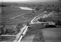
File:Bridgetown Aerial.jpg|Aerial view of [[Bridgetown]], apple warehouses at upper left, [[Bridgetown Bridge|DAR bridge at centre]]. July, 1931. | File:Bridgetown Aerial.jpg|Aerial view of [[Bridgetown]], apple warehouses at upper left, [[Bridgetown Bridge|DAR bridge at centre]]. July, 1931. | ||
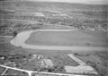
File:BridgetownAerialMcCully311detail.JPG|Detail of aerial view of [[Bridgetown]] with the [[Bridgetown Water Tower|Water Tower]], section house, apple warehouses and station roof, July 1931. | File:BridgetownAerialMcCully311detail.JPG|Detail of aerial view of [[Bridgetown]] with the [[Bridgetown Water Tower|Water Tower]], section house, apple warehouses and station roof, July 1931. | ||
| + | </gallery> | ||
| + | |||
| + | ==Bridgetown Flood 1921== | ||
| + | Heavy rains and two ice jams flooded [[Bridgetown]] on March 14, 1921, submerging over a mile of the DAR mainline and washing out sections of track. The water rose to the wheels of freight cars at the warehouses and flooded the grounds of the the brand new station. The ice destroyed the town's road bridge and almost took out the railway bridge. Work crews from Kentville cleared and rebuilt the tracks. | ||
| + | |||
| + | <gallery> | ||
| + | File:Btown1.jpg|The [[Bridgetown Bridge|Bridgetown Railway Bridge]] during the March 14, 1920 ice jam and flood. | ||
| + | File:Btown3.jpg|The [[Bridgetown]] road bridge collapses during ice jam and flood with the [[Bridgetown Bridge|Railway Bridge]] in distance with the [[Annapolis Valley Cider]] plant on left, Mar. 15, 1920. | ||
| + | File:Btown4.jpeg|DAR work crew arrives with two platform ballast gondolas on the [[Bridgetown Bridge|Bridgetown Railway Bridge]] after the Mar. 14, 1920 ice jam. | ||
| + | </gallery> | ||
| + | |||
| + | ==Later Years== | ||
| + | |||
| + | <gallery> | ||
Image:DAR0044d.jpg|[[DAR0044|No. 44]] at [[Bridgetown]] station in August of 1949. | Image:DAR0044d.jpg|[[DAR0044|No. 44]] at [[Bridgetown]] station in August of 1949. | ||
Image:Bridgetown Station and Yard 1975.jpg|[[Bridgetown Station]] and railyard on July 18, 1975. | Image:Bridgetown Station and Yard 1975.jpg|[[Bridgetown Station]] and railyard on July 18, 1975. | ||
Revision as of 17:29, 27 March 2021
Bridgetown, Nova Scotia
Subdivision Kentville, Mile 44.7
- Next Station East: Paradise
- Next Station West: Tupperville
Facilities & Features
Commerce & Industry
- Acadian Distillers
- Annapolis Valley Cider
- Imperial Oil Bulk Fuel, R. Wagner Agent
Two Apple Warehouses:[1]
- Bridgetown Fruit Company apple warehouse, (1927) 15,000 barrel capy
- Banner Fruit Company apple warehouse, (1927) 15,0000 barrel capy
Description & History
Bridgetown was the head of tide for the Annapolis River which made it an inland navigation points as schooners and later coast steamships could dock on the sheltered river bank. It was also the lowest point in the river that could be bridged which made the village a natural crossroad and early settlement point. The first bridge was built about 1805 and the community became known as Bridgetown in 1825. In addition to farming, early industries included a furniture factory, foundry and brickyard. [2] The Windsor and Annnapolis Railway arrived in 1868, adding a railway bridge just upstream of the long-established road bridge. The railway created an additional commercial district on the south bank of the river with stores and a railway hotel.
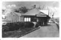
Bridgetown Station with the Bridgetown Bridge in background, circa 1920.
Annapolis Valley Cider Co. Ltd., Bridgetown, July 1931.
Aerial view of Bridgetown, apple warehouses at upper left, DAR bridge at centre. July, 1931.
Detail of aerial view of Bridgetown with the Water Tower, section house, apple warehouses and station roof, July 1931.


Bridgetown Flood 1921
Heavy rains and two ice jams flooded Bridgetown on March 14, 1921, submerging over a mile of the DAR mainline and washing out sections of track. The water rose to the wheels of freight cars at the warehouses and flooded the grounds of the the brand new station. The ice destroyed the town's road bridge and almost took out the railway bridge. Work crews from Kentville cleared and rebuilt the tracks.
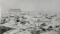
The Bridgetown Railway Bridge during the March 14, 1920 ice jam and flood.
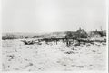
The Bridgetown road bridge collapses during ice jam and flood with the Railway Bridge in distance with the Annapolis Valley Cider plant on left, Mar. 15, 1920.
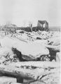
DAR work crew arrives with two platform ballast gondolas on the Bridgetown Railway Bridge after the Mar. 14, 1920 ice jam.


Later Years
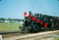
No. 44 at Bridgetown station in August of 1949.
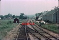
Bridgetown Station and railyard on July 18, 1975.
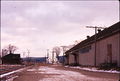
Bridgetown Station left, Co-Op in back, and United Fruit Companies right - February 1976.
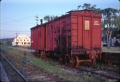
Crew car No. 412201 at Bridgetown in August of 1982.
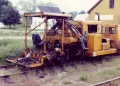
MOW equipment at Bridgetown.


References & Footnotes
- Alexander MacNab, Windsor and Annapolis Railway, Report of Alexander MacNab Nov 1, 1873
- Dominion Atlantic Railway, 1969 Memorandum of General Information, p. 13
Reference Tag
External Links
Bridgetown on Halifax & Southwestern Railway dpi