Dominion Atlantic Railway Digital Preservation Initiative - Wiki
Use of this site is subject to our Terms & Conditions.
Difference between revisions of "Newport"
Dan conlin (talk | contribs) (link) |
Sarah Taylor (talk | contribs) (→Gallery: added File:NewportStationEBay.jpg) |
||
| Line 28: | Line 28: | ||
Image:DAR0018c.jpg|[[DAR0018|"Digby"]] at Mosher's Quarry, at [[Newport]], near Windsor circa 1923. | Image:DAR0018c.jpg|[[DAR0018|"Digby"]] at Mosher's Quarry, at [[Newport]], near Windsor circa 1923. | ||
File:Windsor_21_A16_East.jpg|Topographic map from Falmouth to Ellershouse circa 1956. | File:Windsor_21_A16_East.jpg|Topographic map from Falmouth to Ellershouse circa 1956. | ||
| + | File:NewportStationEBay.jpg|[[Newport]] Station (before closure?). | ||
File:DAR - Newport Station - Harold Jenkins Photo-4December1960.JPG|[[Newport]] Station, photographed by [[:Category:Harold Jenkins Photo|Harold Jenkins]], December 4, 1960. | File:DAR - Newport Station - Harold Jenkins Photo-4December1960.JPG|[[Newport]] Station, photographed by [[:Category:Harold Jenkins Photo|Harold Jenkins]], December 4, 1960. | ||
</Gallery> | </Gallery> | ||
Revision as of 16:10, 27 January 2021
Newport, Nova Scotia
Mile 26.11 from Windsor Junction on the Halifax Subdivision (Mile 41.92 from Halifax)
Elevation: 119 feet above sea level
- Next Station East: Hartville
- Next Station West: Three Mile Plains
Facilities & Features
- Newport Water Tower
- Spur to Moshers Gypsum Quarry at Mile 26.51
Commerce & Industry
Newport was the location of numerous gypsum quarries in the early 20th century, several with spurs to the DAR Mainline.
Description & History
Operations & Orders
Gallery
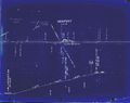
1918 Track Chart of Newport
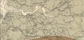
Gypsum quarry spurs in the Windsor, Three Mile Plains, Dimock's and Newport areas, from Canadian geological map, 1909.
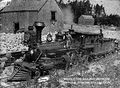
Locomotive No. 4 "St. Croix" with a gypsum train at Moshers Quarry, Newport, date unknown.
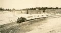
Gypsum Train being loaded, probably at Mosher Quarry in Newport hauled by DAR locomotive No. 25, circa 1920.
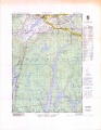
Topographic map from Falmouth to Ellershouse circa 1956.
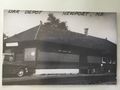
Newport Station (before closure?).
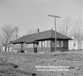
Newport Station, photographed by Harold Jenkins, December 4, 1960.


