Dominion Atlantic Railway Digital Preservation Initiative - Wiki
Use of this site is subject to our Terms & Conditions.
Difference between revisions of "Upper Clements Station"
From DARwiki
Dan conlin (talk | contribs) m |
Dan conlin (talk | contribs) (image) |
||
| Line 8: | Line 8: | ||
File:YA-04.78_Upper_Clements.jpg|Track Chart of Upper Clements showing location of station and platform. | File:YA-04.78_Upper_Clements.jpg|Track Chart of Upper Clements showing location of station and platform. | ||
File:UpperClements1.jpg|[[Upper Clements]] station, looking southeast, Upper Clements spur track in the foreground. | File:UpperClements1.jpg|[[Upper Clements]] station, looking southeast, Upper Clements spur track in the foreground. | ||
| + | File:UpperClements3.jpg|[[Upper Clements Station]], looking southeast with station privy behind, date unknown. | ||
</Gallery> | </Gallery> | ||
[[Category:Stations]] | [[Category:Stations]] | ||
Revision as of 18:57, 3 May 2020
Subdivision Yarmouth, Mile 4.78, Elevation 79'
The station at Upper Clements was a shelter with a platform. While only a one-room shelter, it was finely decorated with architectural details and long overhanging eaves. The station was a scheduled stop from 1894 to 1951
Gallery
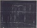
Track Chart of Upper Clements showing location of station and platform.
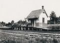
Upper Clements station, looking southeast, Upper Clements spur track in the foreground.
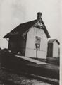
Upper Clements Station, looking southeast with station privy behind, date unknown.


