Dominion Atlantic Railway Digital Preservation Initiative - Wiki
Use of this site is subject to our Terms & Conditions.
Difference between revisions of "Blue Beach Road Overpass"
From DARwiki
m |
|||
| (One intermediate revision by the same user not shown) | |||
| Line 5: | Line 5: | ||
==Gallery== | ==Gallery== | ||
<Gallery> | <Gallery> | ||
| − | File: | + | File:Wolfville_21_H1_East.jpg|Topographic map from Avonport to Shaws Bog circa 1956. |
File:Bluebeachbridge.JPG|Overpass viewed from east, 2011 | File:Bluebeachbridge.JPG|Overpass viewed from east, 2011 | ||
File:Bluebeachbridgedeck.JPG|Overpass ballasted deck looking north, 2011 | File:Bluebeachbridgedeck.JPG|Overpass ballasted deck looking north, 2011 | ||
| Line 14: | Line 14: | ||
[[Category:Bridges]] | [[Category:Bridges]] | ||
| − | [[Category:Subdivision Halifax| | + | [[Category:Subdivision Halifax|HA-41.52]] |
Latest revision as of 12:22, 27 February 2020
Blue Beach Road Overpass
Mile 41.52 on the Halifax Subdivision The DAR passes over the road to Blue Beach on one of the few road overpasses on the DAR, a 52 foot ballasted deck on a timber pile trestle.(1)
Gallery

Topographic map from Avonport to Shaws Bog circa 1956.
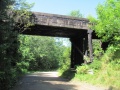
Overpass viewed from east, 2011
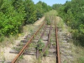
Overpass ballasted deck looking north, 2011


