Dominion Atlantic Railway Digital Preservation Initiative - Wiki
Use of this site is subject to our Terms & Conditions.
Difference between revisions of "Three Mile Plains"
Dan conlin (talk | contribs) m |
Dan conlin (talk | contribs) (→Gallery: image) |
||
| Line 23: | Line 23: | ||
File:Windsor_21_A16_East.jpg|Topographic map from Falmouth to Ellershouse circa 1956. | File:Windsor_21_A16_East.jpg|Topographic map from Falmouth to Ellershouse circa 1956. | ||
File:DAR - Three Mile Plains Station A - Gerald Roach Sr Photo.JPG|The [[Three Mile Plains]] Station, unknown date. | File:DAR - Three Mile Plains Station A - Gerald Roach Sr Photo.JPG|The [[Three Mile Plains]] Station, unknown date. | ||
| + | File:94.1032.jpg|[[Three Mile Plains]] Station with the DAR mainline, undated | ||
</Gallery> | </Gallery> | ||
Revision as of 20:06, 13 February 2020
Three Mile Plains, Nova Scotia
Mile 28.05 from Windsor Junction on the Halifax Subdivision (Mile 43.86 from Halifax)
Elevation: 79 feet above sea level
- Next Station East: Newport
- Next Station West: Pembertons
Facilities & Features
- Passenger Shelter
- Siding (at one time)
Commerce & Industry
A number of gypsum quarries operated around Three Mile Plains which, along with small scale farming, formed the main industry in the community, with many residents also working in nearby Windsor.
Description & History
The community received its named because it is three miles from Windsor and surrounded by views of open fields, as opposed the the forested hills from Newport to Halifax. It became a historic African Nova Scotian community after the War of 1812 when it was settled by refugees from slavery in the United States. [1]
Gallery
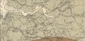
Gypsum quarry spurs in the Windsor, Three Mile Plains, Dimock's and Newport areas, from Canadian geological map, 1909.
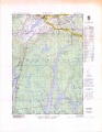
Topographic map from Falmouth to Ellershouse circa 1956.

The Three Mile Plains Station, unknown date.
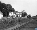
Three Mile Plains Station with the DAR mainline, undated


References & Footnotes
- ↑ C. Bruce Fergusson, "Three Mile Plains", Place-Names and Places of Nova Scotia Nova Scotia Archives (1967), p. 673.