Dominion Atlantic Railway Digital Preservation Initiative - Wiki
Use of this site is subject to our Terms & Conditions.
Difference between revisions of "Waterville"
From DARwiki
Dan conlin (talk | contribs) (details) |
Dan conlin (talk | contribs) (→Gallery: canners) |
||
| Line 20: | Line 20: | ||
<Gallery perrow=5> | <Gallery perrow=5> | ||
File:Berwick 21 H2 East.jpg|Topographic map from Berwick to Kentville circa 1956. | File:Berwick 21 H2 East.jpg|Topographic map from Berwick to Kentville circa 1956. | ||
| − | File:DAR - Waterville Station - Harold Jenkins Photo-August1958.JPG|The [[Waterville Station]] looking west, | + | File:DAR - Waterville Station - Harold Jenkins Photo-August1958.JPG|The [[Waterville Station]] looking west, with the Annapolis Valley Canners buildings on the left, 1958. |
| − | File:Water10008.JPG|VIA Rail shelter at [[Waterville]] | + | File:Water10008.JPG|VIA Rail shelter at [[Waterville]] with the Annapolis Valley Canners buildings in the background, April 1986. |
</gallery> | </gallery> | ||
Revision as of 16:02, 4 May 2019
Subdivision Kentville, Mile 9.3
Facilities & Features
- Waterville Station
- 850' siding
- 600' blind siding
- Wood shed 22' x 15'[1]
Commerce & Industry
- Annapolis Valley Canners Limited: canning factory, apples and small fruits
- Four apple warehouses
Description & History
Originally known as Pineo Village, it wad renamed "Waterville" in 1871 shortly after the arrival of the Windsor & Annapolis Railway in 1869.[2] It was an early centre of agriculture and received one of the larger stations along the Windsor & Annapolis.
Gallery
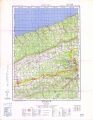
Topographic map from Berwick to Kentville circa 1956.
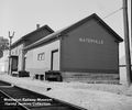
The Waterville Station looking west, with the Annapolis Valley Canners buildings on the left, 1958.
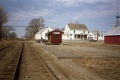
VIA Rail shelter at Waterville with the Annapolis Valley Canners buildings in the background, April 1986.


