Dominion Atlantic Railway Digital Preservation Initiative - Wiki
Use of this site is subject to our Terms & Conditions.
Difference between revisions of "Doddridge"
From DARwiki
Dan conlin (talk | contribs) (history) |
|||
| (8 intermediate revisions by 2 users not shown) | |||
| Line 6: | Line 6: | ||
[[:Category:Subdivision Truro|Subdivision Truro]], Mile 31.56 | [[:Category:Subdivision Truro|Subdivision Truro]], Mile 31.56 | ||
| − | Next Station | + | Next Station East: [[Burtons]] |
| − | Next Station | + | Next Station West: [[Upper Kennetcook]] |
==Facilities & Features== | ==Facilities & Features== | ||
| − | + | Doddridge Station, Mile 31.56 | |
| + | |||
| + | 50 ft. Half Deck Plate Girder and Pile Trestle Bridge over the Kennetcook River Bridge, Mile 31.33 | ||
| + | |||
| + | ==Description & History== | ||
| + | Doddridge is a small farming community at the head of the Kennetcook River. It was settled around the War of 1812 and named after Philip Doddridge, an English religious leader.<ref>[https://novascotia.ca/archives/places/page.asp?ID=172 C. Bruce Fergusson, "Burton"], ''Place-Names and Places of Nova Scotia'' Nova Scotia Archives (1967), p. 172.</ref> | ||
==Gallery== | ==Gallery== | ||
<Gallery> | <Gallery> | ||
Image:DAR Midland Div near Dodds Bridge, NS 8-1-1958.jpg|[[:Category:Subdivision Truro|Midland line]] near [[Doddridge]], NS. from the rear of [[Train No. 22]] on August 1, 1958. | Image:DAR Midland Div near Dodds Bridge, NS 8-1-1958.jpg|[[:Category:Subdivision Truro|Midland line]] near [[Doddridge]], NS. from the rear of [[Train No. 22]] on August 1, 1958. | ||
| + | File:DAR - Doddridge Station-Harold Jenkins Photo-June1959.JPG|[[Doddridge]] Station, photographed by [[:Category:Harold Jenkins Photo|Harold Jenkins]], June 1959. | ||
</Gallery> | </Gallery> | ||
| + | |||
| + | <!-- | ||
| + | For References, please list general references first. Leave the "cite" wiki markup in at the end and use the cite "<ref> and </ref> right in the text to footnote specific items. The Memorandum reference should be left unless the location or structures listed do not show up in the memorandum. | ||
| + | --> | ||
| + | ==References & Footnotes== | ||
| + | *[[1969-MemoOfGenInfo|1969 Memorandum of General Information, page 22]] | ||
| + | <references /> | ||
| + | |||
| + | ==Reference Tag== | ||
| + | <!-- | ||
| + | If this article is commonly linked to, include a string that describes and can be copied and used to refer to this article such as for example: | ||
| + | |||
| + | Please use this tag when referring to this article: Scotian Railroad Society, ''[[Zzzz Location Template|DAR Wiki Location Template]]'' | ||
| + | --> | ||
| + | ==External Links== | ||
[[Category:Locations]] | [[Category:Locations]] | ||
| − | [[Category:Subdivision Truro| | + | [[Category:Subdivision Truro|315]] |
Latest revision as of 17:40, 17 October 2018
Doddridge, Nova Scotia
Subdivision Truro, Mile 31.56
Next Station East: Burtons
Next Station West: Upper Kennetcook
Facilities & Features
Doddridge Station, Mile 31.56
50 ft. Half Deck Plate Girder and Pile Trestle Bridge over the Kennetcook River Bridge, Mile 31.33
Description & History
Doddridge is a small farming community at the head of the Kennetcook River. It was settled around the War of 1812 and named after Philip Doddridge, an English religious leader.[1]
Gallery
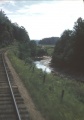
Midland line near Doddridge, NS. from the rear of Train No. 22 on August 1, 1958.
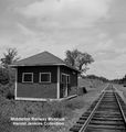
Doddridge Station, photographed by Harold Jenkins, June 1959.


References & Footnotes
- ↑ C. Bruce Fergusson, "Burton", Place-Names and Places of Nova Scotia Nova Scotia Archives (1967), p. 172.