Dominion Atlantic Railway Digital Preservation Initiative - Wiki
Use of this site is subject to our Terms & Conditions.
Difference between revisions of "Avonport"
From DARwiki
Dan conlin (talk | contribs) (image) |
|||
| Line 16: | Line 16: | ||
==Gallery== | ==Gallery== | ||
<Gallery perrow=5> | <Gallery perrow=5> | ||
| + | File:Wolfville_21_H1_East.jpg|Topographic map from Avonport to Shaws Bog circa 1956. | ||
Image:Gaspereaux River Bridge a.jpg|The [[Gaspereaux River Bridge]] looking east over the Gaspereaux River at [[Horton Landing|Hortonville]] with [[Avonport]] in the distance. | Image:Gaspereaux River Bridge a.jpg|The [[Gaspereaux River Bridge]] looking east over the Gaspereaux River at [[Horton Landing|Hortonville]] with [[Avonport]] in the distance. | ||
| − | File: | + | File:DAR - Avonport Station and Sign-Harold Jenkins Photo-18November1962.JPG|[[Avonport]] old station and station flagstop sign, November 18, 1962. |
</Gallery> | </Gallery> | ||
Revision as of 20:41, 7 October 2018
Avonport, Nova Scotia
Mile 43.45 from Windsor Junction on the Halifax Subdivision (Mile 59.26 from Halifax)
- Next Station East: Hantsport
- Next Station West: Horton Landing
Facilities & Features
Commerce & Industry
Description & History
Operations & Orders
Gallery

Topographic map from Avonport to Shaws Bog circa 1956.
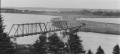
The Gaspereaux River Bridge looking east over the Gaspereaux River at Hortonville with Avonport in the distance.

Avonport old station and station flagstop sign, November 18, 1962.


References & Footnotes
- Alexander MacNab, Windsor and Annapolis Railway, Report of Alexander MacNab Nov 1, 1873
- 1969 Memorandum of General Information