Dominion Atlantic Railway Digital Preservation Initiative - Wiki
Use of this site is subject to our Terms & Conditions.
Difference between revisions of "Deep Brook"
From DARwiki
Dan conlin (talk | contribs) (→Gallery: images) |
|||
| Line 11: | Line 11: | ||
<Gallery> | <Gallery> | ||
Image:YA-10.40 Deep Brook.jpg|Track Schematic for Deep Brook. | Image:YA-10.40 Deep Brook.jpg|Track Schematic for Deep Brook. | ||
| + | Image:Deep Brook Shed a.jpg|The gypsum storage shed and dock at Deep Brook. | ||
| + | File:DeepBrookGypsumLoaderMap.jpg|Map showing the Gypsum loader spur and dock. | ||
| + | File:DeepBrookGypsumLoader.jpg|Aerial View showing the remnants of the Gypsum loader spur and dock. | ||
</Gallery> | </Gallery> | ||
| + | |||
[[Category:Locations]] | [[Category:Locations]] | ||
[[Category:Subdivision Yarmouth|Y104]] | [[Category:Subdivision Yarmouth|Y104]] | ||
Revision as of 18:51, 15 September 2018
Deep Brook, Nova Scotia
- Subdivision Yarmouth, Mile 10.4
- Elevation unknown
- Passing track 915' long.
Features and Facilities
Gallery
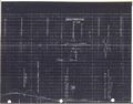
Track Schematic for Deep Brook.
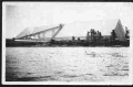
The gypsum storage shed and dock at Deep Brook.
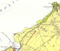
Map showing the Gypsum loader spur and dock.
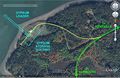
Aerial View showing the remnants of the Gypsum loader spur and dock.


