Dominion Atlantic Railway Digital Preservation Initiative - Wiki
Use of this site is subject to our Terms & Conditions.
Difference between revisions of "Brooklyn"
From DARwiki
Dan conlin (talk | contribs) (→Gallery: image) |
|||
| Line 20: | Line 20: | ||
==Gallery== | ==Gallery== | ||
<Gallery> | <Gallery> | ||
| + | File:Quarries.jpg|[[:Category:Gypsum_Trains|gypsum quarry]] spurs in the [[Windsor]], [[Dimock's]], [[Brooklyn]] and [[Newport]] areas, from geological map, 1909. | ||
File:Wolfville_21_H1_East.jpg|Topographic map from Avonport to Shaws Bog circa 1956. | File:Wolfville_21_H1_East.jpg|Topographic map from Avonport to Shaws Bog circa 1956. | ||
</Gallery> | </Gallery> | ||
| Line 26: | Line 27: | ||
For References, please list general references first. Leave the "cite" wiki markup in at the end and use the cite "<ref> and </ref> right in the text to footnote specific items. The Memorandum reference should be left unless the location or structures listed do not show up in the memorandum. | For References, please list general references first. Leave the "cite" wiki markup in at the end and use the cite "<ref> and </ref> right in the text to footnote specific items. The Memorandum reference should be left unless the location or structures listed do not show up in the memorandum. | ||
--> | --> | ||
| + | |||
==References & Footnotes== | ==References & Footnotes== | ||
*[[1969-MemoOfGenInfo|1969 Memorandum of General Information]] | *[[1969-MemoOfGenInfo|1969 Memorandum of General Information]] | ||
Revision as of 16:17, 30 April 2017
Brooklyn, Hants County, Nova Scotia
Subdivision Truro, Mile 6.18
Next Station West: Scotch Village
Next Station East: Mantua
Facilities & Features
Description & History
Operations & Orders
Gallery
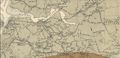
gypsum quarry spurs in the Windsor, Dimock's, Brooklyn and Newport areas, from geological map, 1909.

Topographic map from Avonport to Shaws Bog circa 1956.

