Dominion Atlantic Railway Digital Preservation Initiative - Wiki
Use of this site is subject to our Terms & Conditions.
Difference between revisions of "Church Point"
From DARwiki
(New page: =Church Point, Nova Scotia= Subdivision 4 Yarmouth, Mile 50.2 <Gallery> </Gallery> Category:Locations 411) |
|||
| (5 intermediate revisions by one other user not shown) | |||
| Line 1: | Line 1: | ||
=Church Point, Nova Scotia= | =Church Point, Nova Scotia= | ||
| − | Subdivision | + | *Subdivision Yarmouth, Mile 50.2 |
| + | *Elevation 154' | ||
| + | *Passing track 900' long (1969) | ||
| + | |||
| + | ==Facilities and Features== | ||
| + | [[Church Point Station]] | ||
| + | |||
| + | ==Gallery== | ||
<Gallery> | <Gallery> | ||
| + | File:15965810 10154978591401789 5450450359696675718 n.jpg|Church Point, 1929. | ||
</Gallery> | </Gallery> | ||
| + | |||
[[Category:Locations]] | [[Category:Locations]] | ||
| − | [[Category:Subdivision | + | [[Category:Subdivision Yarmouth|Y502]] |
Latest revision as of 20:57, 7 February 2017
Church Point, Nova Scotia
- Subdivision Yarmouth, Mile 50.2
- Elevation 154'
- Passing track 900' long (1969)
Facilities and Features
Gallery
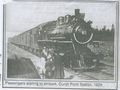
Church Point, 1929.
