Dominion Atlantic Railway Digital Preservation Initiative - Wiki
Use of this site is subject to our Terms & Conditions.
Difference between revisions of "Port Williams"
Samuelmclark (talk | contribs) |
|||
| Line 25: | Line 25: | ||
==Gallery== | ==Gallery== | ||
<Gallery perrow=5> | <Gallery perrow=5> | ||
| + | File:Wolfville_21_H1_West.jpg|Topographic map from Kentville to Hortons Landing circa 1956. | ||
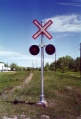
| + | Image:Crossbuck at Greenwich July 1993.jpg|Looking railway east. | ||
| + | Image:DAR Greenwich looking east July 1994.jpg|Looking railway east. | ||
| + | Image:DAR Greenwich looking west July 1994.jpg|Looking railway west from [[Greenwich CO-OP]] spur. | ||
| + | Image:DAR Greenwich1 July 1994.jpg|West end of Halifax Sub. 1994. | ||
File:Wolfville_21_H1_West.jpg|Topographic map from Kentville to Hortons Landing circa 1956. | File:Wolfville_21_H1_West.jpg|Topographic map from Kentville to Hortons Landing circa 1956. | ||
</gallery> | </gallery> | ||
Revision as of 14:29, 27 December 2013
Port Williams, Nova Scotia
Mile 51.4 from Windsor Junction on the Halifax Subdivision (Mile 67.15 from Halifax)
Facilities & Features
Commerce & Industry
The village of Port Williams was actually on the other side of the Cornwallis River but connected by a bridge to the Port Williams Station and several large businesses served by the DAR. Before WW II, they included five Apple Warehouses including some of the first first apple warehouses built on the DAR.[1]. After WW II, Port Williams hosted two large poultry producers, C&M Ells and Archibald Farms Limited as well as Canada Packers flour, feed and poultry plant and the Canadian Petrofina, later West Nova bulk fuel plant.
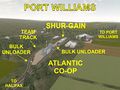
Port Williams (Greenwich) industries circa 1975.
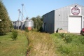
Port Williams looking east on August 30, 2011.

.jpg)
Description & History
Operations & Orders
Gallery
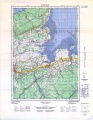
Topographic map from Kentville to Hortons Landing circa 1956.
Looking railway east.
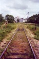
Looking railway east.
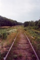
Looking railway west from Greenwich CO-OP spur.

West end of Halifax Sub. 1994.
Topographic map from Kentville to Hortons Landing circa 1956.


References & Footnotes
- Alexander MacNab, Windsor and Annapolis Railway, Report of Alexander MacNab Nov 1, 1873
- 1969 Memorandum of General Information
- ↑ Willard Longley Map, Some Economic Aspects of the Apple Industry in Nova Scotia